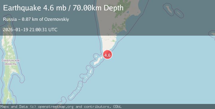
Earthquake NEAR EAST COAST OF KAMCHATKA
Mon, 19 Jan 2026 21:00:31 GMT
Time1 month ago
Location
51.0405, 157.2407
Depth
70.0 KM
Event Summary
A 4.6 magnitude earthquake struck on NEAR EAST COAST OF KAMCHATKA, at Mon, 19 Jan 2026 21:00:31 GMT. Depth: 70km. Reviewed by EMSC seismologists, this light quake occurred at a magnitude type of mb.
Magnitude
4.6
mb
Source
EMSC
Intensity
-
Agency Reports
1 Sources| Source | Magnitude | Depth | Time |
|---|---|---|---|
| EMSCPrimary | 4.6 | 70 km | 1 month ago |
Earthquake Details
AutomaticEvent IDemsc_EMSC_20260119_0000297
Tsunami PotentialNo
Magnitude Typemb
Nearest Places
- 15.6 km
- 15.8 km
- 15.9 km
- 16.4 km
- 16.4 km
Comments
Join the discussion about this event.
Latest Earthquakes
3.3Mag
Sumba region, Indonesia
Time19 hours ago
Depth17.09 km
SourceVYT (Automatic)
3.2Mag
West Papua Region, Indonesia
Time19 hours ago
Depth10.00 km
SourceBMKG
1.4Mag
Southeastern Alaska
Time19 hours ago
Depth0.00 km
SourceVYT (Automatic)
3.1Mag
ANTOFAGASTA, CHILE
Time19 hours ago
Depth194.50 km
SourceCSN (Automatic)
2.4Mag
Central California
Time19 hours ago
Depth0.00 km
SourceVYT (Automatic)
Nearby Earthquakes
4.0Mag
KURIL ISLANDS
Time3 months ago
Depth79.90 km
SourceNEIC (Automatic)
5.3Mag
KURIL ISLANDS
Time8 years ago
Depth60.00 km
SourceEMSC (Automatic)
4.0Mag
NEAR EAST COAST OF KAMCHATKA
Time5 years ago
Depth140.00 km
SourceOBN (Automatic)
6.8Mag
KURIL ISLANDS
Time12 years ago
Depth60.00 km
SourceEMSC (Automatic)
5.8Mag
KURIL ISLANDS
Time12 years ago
Depth48.00 km
SourceEMSC (Automatic)