Earthquake BANDA SEA
Thu, 29 Jan 2026 21:52:56 GMT
Time2 weeks ago
Location
-6.9813, 129.9731
Depth
150.0 KM
Event Summary
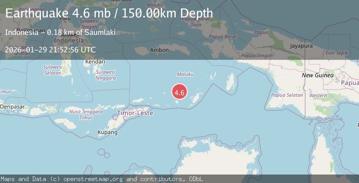
A 4.6 magnitude earthquake struck on BANDA SEA, at Thu, 29 Jan 2026 21:52:56 GMT. Depth: 150km. Reviewed by EMSC seismologists, this light quake occurred at a magnitude type of mb.
Magnitude
4.6
mb
Source
EMSC
Intensity
-
Agency Reports
1 Sources| Source | Magnitude | Depth | Time |
|---|---|---|---|
| EMSCPrimary | 4.6 | 150 km | 2 weeks ago |
Earthquake Details
AutomaticEvent IDemsc_EMSC_20260129_0000300
Tsunami PotentialNo
Magnitude Typemb
Nearest Places
- Nil Desperandum46.0 km
- Damar Ridge54.8 km
- Rumadai56.5 km
- Tanjung Sifanandrierna56.6 km
- Wotai57.7 km
Comments
Join the discussion about this event.
Latest Earthquakes
1.0Mag
29 km W of Garden City, Texas
Time4 minutes ago
Depth3.03 km
SourceUSGS (Automatic)
2.1Mag
6 km NE of Beaverdam, Nevada
Time6 minutes ago
Depth11.45 km
SourceUSGS (Automatic)
3.4Mag
NORTH ISLAND OF NEW ZEALAND
Time12 minutes ago
Depth146.90 km
SourceGNS (Automatic)
2.6Mag
WESTERN TURKEY
Time19 minutes ago
Depth7.30 km
SourceKOERI (Automatic)
3.7Mag
YUNNAN, CHINA
Time20 minutes ago
Depth10.00 km
SourceTSB (Automatic)
Nearby Earthquakes
5.0Mag
KEPULAUAN BABAR, INDONESIA
Time10 years ago
Depth141.00 km
SourceEMSC (Automatic)
3.6Mag
BANDA SEA
Time1 month ago
Depth115.00 km
SourceBMKG (Automatic)
5.2Mag
KEPULAUAN BABAR, INDONESIA
Time16 years ago
Depth116.00 km
SourceEMSC (Automatic)
3.6Mag
KEPULAUAN BABAR, INDONESIA
Time1 month ago
Depth162.00 km
SourceBMKG (Automatic)
7.6Mag
KEPULAUAN BABAR, INDONESIA
Time3 years ago
Depth104.00 km
SourceEMSC (Automatic)