Earthquake SOUTHERN IRAN
Fri, 13 Feb 2026 16:03:03 GMT
Time5 months ago
Location
28.0888, 57.3607
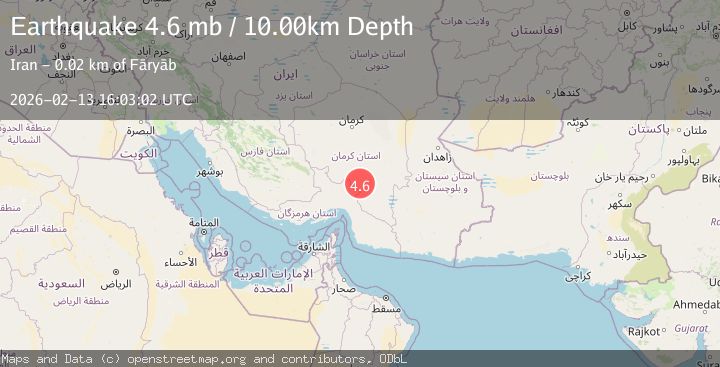
Depth
27.0 KM
Event Summary
A 4.7 magnitude earthquake struck on SOUTHERN IRAN, at Fri, 13 Feb 2026 16:03:03 GMT. Depth: 27km. Reviewed by EMSC seismologists, this light quake occurred at a magnitude type of mb.
Magnitude
4.7
mb
Source
EMSC
Intensity
IV
Agency Reports
3 Sources| Source | Magnitude | Depth | Time |
|---|---|---|---|
| GSRASPrimary | 4.6 | 10 km | 5 months ago |
| EMSC | 4.7 | 27 km | 5 months ago+1s |
| NEIC | 4.6 | 77 km | 5 months ago+7s |
Earthquake Details
AutomaticEvent IDemsc_EMSC_20260213_0000251
QualityS
Tsunami PotentialNo
Magnitude Typemb
Last Update5 months ago
Nearest Places
Possibly felt by: 94.8K
- IVFāryāb12.7 km
- IVKahnūj36.6 km
- IIIRūdbār62.7 km
- III‘Anbarābād64.3 km
- IIIRūdān73.8 km
- IIIJīroft75.3 km
- IIIManūjān77.1 km
- IIIQal‘eh Ganj81.0 km
- 106.0 km
- IIMīnāb109.9 km70.8K people
- IIRābor140.7 km
- 142.9 km2.9K people
- 145.1 km23.3K people
- 146.2 km352.2K people
- IIBāft147.2 km
- IBam149.2 km99.3K people
- 162.1 km
- 166.3 km25K people
- 177.1 km
- 179.5 km
- 189.3 km
- 215.9 km
- 216.0 km
- 217.8 km37.2K people
- 223.1 km207.6K people
- 236.9 km5K people
- 239.1 km17.9K people
Felt Reports0
Did you feel this earthquake? Report it to help others.
No reports yet
Be the first to report this earthquake!
Latest Earthquakes
Loading...
Nearby Earthquakes
4.4Mag
SOUTHERN IRAN
Time1 week ago
Depth10.00 km
SourceGFZ (Automatic)
4.2Mag
SOUTHERN IRAN
Time1 month ago
Depth87.20 km
SourceNEIC (Automatic)
4.0Mag
SOUTHERN IRAN
Time2 months ago
Depth10.00 km
SourceNEIC (Automatic)
4.6Mag
SOUTHERN IRAN
Time2 months ago
Depth23.00 km
SourceEMSC (Automatic)
4.7Mag
110 km N of Mīnāb, Iran
Time6 months ago
Depth46.21 km
SourceUSGS