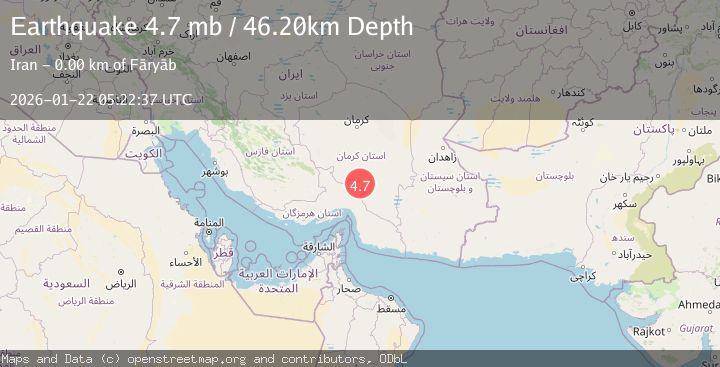
Earthquake 110 km N of Mīnāb, Iran
Thu, 22 Jan 2026 05:22:37 GMT
Time6 months ago
Location
28.1153, 57.2527
Depth
46.2 KM
Event Summary
A 4.7 magnitude earthquake struck on 110 km N of Mīnāb, Iran, at Thu, 22 Jan 2026 05:22:37 GMT. Depth: 46.206km. Reviewed by USGS seismologists, this light quake occurred at a magnitude type of mb.
Magnitude
4.7
mb
Source
USGS
Intensity
IV
Agency Reports
3 Sources| Source | Magnitude | Depth | Time |
|---|---|---|---|
| EMSCPrimary | 4.7 | 41 km | 6 months ago |
| NEIC | 4.7 | 46 km | 6 months ago0s |
| USGS | 4.7 | 46 km | 6 months ago0s |
Earthquake Details
ConfirmedEvent IDusgs_us7000rr9p
QualityS
Tsunami PotentialNo
Magnitude Typemb
Last Update5 months ago
Nearest Places
Possibly felt by: 138K
- IVFāryāb2.8 km
- IIIKahnūj47.5 km
- III‘Anbarābād70.8 km
- IIIRūdbār73.6 km
- IIIRūdān75.1 km
- IIIJīroft78.7 km
- IIManūjān82.5 km
- 90.3 km
- 95.2 km
- IIMīnāb110.7 km70.8K people
- 134.1 km23.3K people
- IIRābor134.9 km
- 136.4 km2.9K people
- IIBāft139.6 km
- 140.8 km352.2K people
- IBam154.1 km99.3K people
- 161.9 km25K people
- 169.1 km
- 184.5 km
- 188.4 km
- 195.4 km
- 209.2 km
- 211.5 km37.2K people
- 213.4 km207.6K people
- 227.0 km
- 234.8 km5K people
- 237.1 km17.9K people
- 241.7 km577.5K people
Felt Reports0
Did you feel this earthquake? Report it to help others.
No reports yet
Be the first to report this earthquake!
Latest Earthquakes
Loading...
Nearby Earthquakes
4.4Mag
SOUTHERN IRAN
Time1 week ago
Depth10.00 km
SourceGFZ (Automatic)
4.2Mag
SOUTHERN IRAN
Time1 month ago
Depth87.20 km
SourceNEIC (Automatic)
4.0Mag
SOUTHERN IRAN
Time2 months ago
Depth10.00 km
SourceNEIC (Automatic)
4.6Mag
SOUTHERN IRAN
Time2 months ago
Depth23.00 km
SourceEMSC (Automatic)
4.7Mag
SOUTHERN IRAN
Time5 months ago
Depth27.00 km
SourceEMSC (Automatic)