Earthquake EASTERN NEW GUINEA REG., P.N.G.
Thu, 29 Jan 2026 07:54:50 GMT
Time2 months ago
Location
-6.5640, 147.9400
Depth
87.5 KM
Event Summary
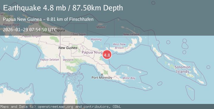
A 4.8 magnitude earthquake struck on EASTERN NEW GUINEA REG., P.N.G., at Thu, 29 Jan 2026 07:54:50 GMT. Depth: 87.5km. Reviewed by GFZ seismologists, this light quake occurred at a magnitude type of mb.
Magnitude
4.8
mb
Source
GFZ
Intensity
III
Agency Reports
2 Sources| Source | Magnitude | Depth | Time |
|---|---|---|---|
| GFZPrimary | 4.8 | 88 km | 2 months ago |
| EMSC | 4.9 | 70 km | 2 months ago |
Earthquake Details
AutomaticEvent IDemsc_GFZ_20260129_0000112
QualityS
Tsunami PotentialNo
Magnitude Typemb
Last Update2 months ago
Nearest Places
Possibly felt by: 24.8K
- IIIFinschhafen11.1 km1.1K people
- IILae105.8 km76.3K people
- IIWau159.7 km14.6K people
- IIBulolo160.2 km16K people
- 182.0 km1K people
- 231.3 km8.5K people
- 246.9 km28.2K people
- 258.3 km6.2K people
- 267.9 km18.8K people
- 281.1 km27.4K people
Felt Reports0
Did you feel this earthquake? Report it to help others.
No reports yet
Be the first to report this earthquake!
Latest Earthquakes
Loading...
Nearby Earthquakes
5.4Mag
New Britain Region, Papua New Guinea
Time2 days ago
Depth22.31 km
SourceBMKG
4.9Mag
eastern New Guinea region, Papua New Guinea
Time2 weeks ago
Depth60.30 km
SourceVYT (Automatic)
3.5Mag
eastern New Guinea region, Papua New Guinea
Time3 weeks ago
Depth0.00 km
SourceVYT (Automatic)
3.0Mag
New Britain region, Papua New Guinea
Time1 month ago
Depth375.12 km
SourceVYT (Automatic)
4.9Mag
NEW BRITAIN REGION, P.N.G.
Time2 months ago
Depth104.30 km
SourceNEIC (Automatic)