Earthquake SOUTH ISLAND OF NEW ZEALAND
Sat, 17 Jan 2026 18:20:26 GMT
Time1 month ago
Location
-41.0949, 173.9957
Depth
37.4 KM
Event Summary
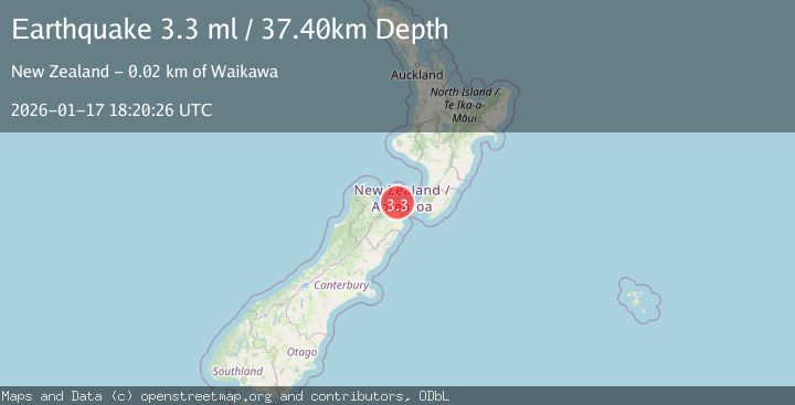
A 3.3 magnitude earthquake struck on SOUTH ISLAND OF NEW ZEALAND, at Sat, 17 Jan 2026 18:20:26 GMT. Depth: 37.4km. Reviewed by GNS seismologists, this minor quake occurred at a magnitude type of ml.
Magnitude
3.3
ml
Source
GNS
Intensity
-
Agency Reports
1 Sources| Source | Magnitude | Depth | Time |
|---|---|---|---|
| GNSPrimary | 3.3 | 37 km | 1 month ago |
Earthquake Details
AutomaticEvent IDemsc_GNS_20260117_0000205
Tsunami PotentialNo
Magnitude Typeml
Nearest Places
- Grant Bay0.8 km
- Hopai Bay1.4 km
- Opani-aputa Point1.6 km
- Ouokaha Island2.3 km
- Manaroa2.5 km
Comments
Join the discussion about this event.
Latest Earthquakes
1.4Mag
Southeastern Alaska
Time5 hours ago
Depth0.00 km
SourceVYT (Automatic)
3.0Mag
northern Sumatra, Indonesia
Time5 hours ago
Depth10.50 km
SourceVYT (Automatic)
1.6Mag
Kenai Peninsula, Alaska
Time5 hours ago
Depth42.60 km
SourceVYT (Automatic)
2.4Mag
Finland
Time5 hours ago
Depth301.88 km
SourceVYT (Automatic)
1.2Mag
Alaska Peninsula
Time5 hours ago
Depth0.12 km
SourceVYT (Automatic)
Nearby Earthquakes
3.1Mag
COOK STRAIT, NEW ZEALAND
Time1 month ago
Depth52.10 km
SourceGNS (Automatic)
3.0Mag
SOUTH ISLAND OF NEW ZEALAND
Time3 years ago
Depth56.00 km
SourceGNS (Automatic)
4.0Mag
COOK STRAIT, NEW ZEALAND
Time4 years ago
Depth60.00 km
SourceGNS (Automatic)
3.0Mag
SOUTH ISLAND OF NEW ZEALAND
Time4 years ago
Depth34.00 km
SourceGNS (Automatic)
3.0Mag
COOK STRAIT, NEW ZEALAND
Time1 year ago
Depth33.40 km
SourceGNS (Automatic)