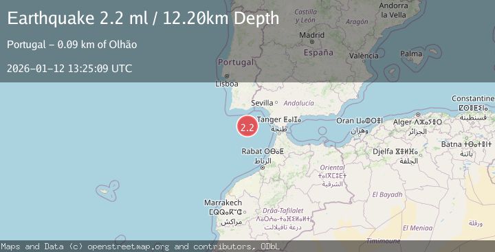
Earthquake STRAIT OF GIBRALTAR
Mon, 12 Jan 2026 13:25:09 GMT
Time1 month ago
Location
36.1968, -7.7847
Depth
12.2 KM
Event Summary
A 2.2 magnitude earthquake struck on STRAIT OF GIBRALTAR, at Mon, 12 Jan 2026 13:25:09 GMT. Depth: 12.2km. Reviewed by IGN seismologists, this minor quake occurred at a magnitude type of ml.
Magnitude
2.2
ml
Source
IGN
Intensity
-
Agency Reports
1 Sources| Source | Magnitude | Depth | Time |
|---|---|---|---|
| IGNPrimary | 2.2 | 12 km | 1 month ago |
Earthquake Details
AutomaticEvent IDemsc_IGN_20260112_0000202
Tsunami PotentialNo
Magnitude Typeml
Nearest Places
- Faro Canyon24.6 km
- Ribeira da Pardiela32.8 km
- Cabo de Santa Maria85.4 km
- Barra Nova85.6 km
- Praia Da Ilha Deserta85.7 km
Comments
Join the discussion about this event.
Latest Earthquakes
4.5Mag
North of Halmahera, Indonesia
Time1 hour ago
Depth10.00 km
SourceBMKG
3.1Mag
Bali Region, Indonesia
Time1 hour ago
Depth19.14 km
SourceBMKG
2.7Mag
Coquimbo, Chile
Time1 hour ago
Depth14.16 km
SourceVYT (Automatic)
1.7Mag
Southeastern Alaska
Time1 hour ago
Depth5.98 km
SourceVYT (Automatic)
2.1Mag
Tarapaca, Chile
Time1 hour ago
Depth110.35 km
SourceVYT (Automatic)
Nearby Earthquakes
3.0Mag
STRAIT OF GIBRALTAR
Time5 years ago
Depth10.00 km
SourceEMSC (Automatic)
2.9Mag
STRAIT OF GIBRALTAR
Time1 month ago
Depth15.00 km
SourceEMSC (Automatic)
3.0Mag
STRAIT OF GIBRALTAR
Time2 years ago
Depth15.00 km
SourceEMSC (Automatic)
3.0Mag
STRAIT OF GIBRALTAR
Time19 years ago
Depth40.00 km
SourceEMSC (Automatic)
3.0Mag
STRAIT OF GIBRALTAR
Time17 years ago
Depth60.00 km
SourceEMSC (Automatic)