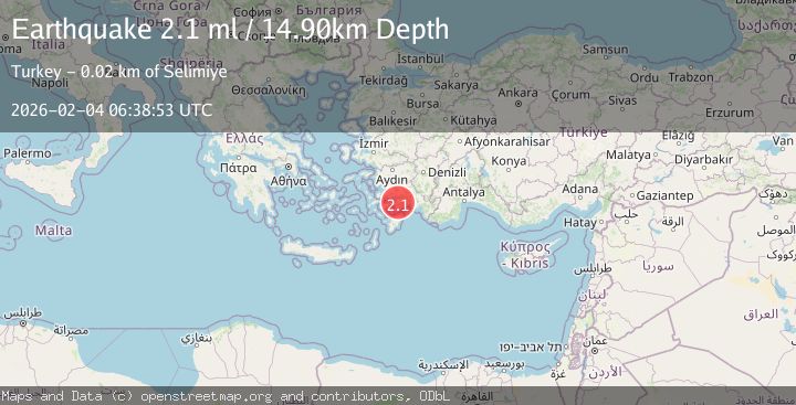
Earthquake DODECANESE IS.-TURKEY BORDER REG
Wed, 04 Feb 2026 06:38:54 GMT
Time8 hours ago
Location
36.8522, 28.0713
Depth
3.3 KM
Event Summary
A 2.3 magnitude earthquake struck on DODECANESE IS.-TURKEY BORDER REG, at Wed, 04 Feb 2026 06:38:54 GMT. Depth: 3.3km. Reviewed by KOERI seismologists, this minor quake occurred at a magnitude type of ml.
Magnitude
2.3
ml
Source
KOERI
Intensity
-
Agency Reports
1 Sources| Source | Magnitude | Depth | Time |
|---|---|---|---|
| KOERIPrimary | 2.3 | 3 km | 8 hours ago |
Earthquake Details
AutomaticEvent IDemsc_KOERI_20260204_0000085
Tsunami PotentialNo
Magnitude Typeml
Nearest Places
- Hatip Pınarı1.6 km
- Aşağıbörtlen2.2 km
- Saklı Limanı2.5 km
- Gökağaçbaşı Tepesi2.8 km
- Karaağaç Limanı2.9 km
Comments
Join the discussion about this event.
Latest Earthquakes
1.2Mag
WESTERN TURKEY
Time8 hours ago
Depth12.60 km
SourceAFAD (Automatic)
0.6Mag
SWITZERLAND
Time8 hours ago
Depth1.60 km
SourceETHZ (Automatic)
2.5Mag
Sumba Region, Indonesia
Time8 hours ago
Depth61.17 km
SourceBMKG (Automatic)
1.9Mag
4 km SE of San Ramon, CA
Time8 hours ago
Depth8.44 km
SourceUSGS (Automatic)
3.0Mag
WESTERN AUSTRALIA
Time8 hours ago
Depth10.00 km
SourceAUST (Automatic)
Nearby Earthquakes
2.3Mag
DODECANESE IS.-TURKEY BORDER REG
Time1 week ago
Depth7.20 km
SourceAFAD (Automatic)
2.0Mag
DODECANESE IS.-TURKEY BORDER REG
Time1 week ago
Depth3.90 km
SourceKOERI (Automatic)
2.0Mag
WESTERN TURKEY
Time1 week ago
Depth17.80 km
SourceKOERI (Automatic)
1.6Mag
WESTERN TURKEY
Time6 days ago
Depth7.00 km
SourceEMSC (Automatic)
1.4Mag
DODECANESE IS.-TURKEY BORDER REG
Time3 days ago
Depth7.00 km
SourceAFAD (Automatic)