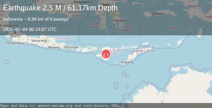
Earthquake Sumba Region, Indonesia
Wed, 04 Feb 2026 06:14:06 GMT
Time8 hours ago
Location
-9.4648, 120.3259
Depth
82.8 KM
Event Summary
A 2.4 magnitude earthquake struck on Sumba Region, Indonesia, at Wed, 04 Feb 2026 06:14:06 GMT. Depth: 82.768547km. Reviewed by BMKG seismologists, this minor quake occurred at a magnitude type of M.
Magnitude
2.4
M
Source
BMKG
Intensity
-
Agency Reports
1 Sources| Source | Magnitude | Depth | Time |
|---|---|---|---|
| BMKGPrimary | 2.4 | 83 km | 8 hours ago |
Earthquake Details
AutomaticEvent IDbmg2026ckpl
Tsunami PotentialNo
Magnitude TypeM
Nearest Places
- Luku Patekiwatutila13.1 km
- Luku Maudulung13.6 km
- Luku Ananahu13.6 km
- Maudulung13.6 km
- Luku Karuakapu13.9 km
Comments
Join the discussion about this event.
Latest Earthquakes
1.9Mag
4 km SE of San Ramon, CA
Time8 hours ago
Depth8.44 km
SourceUSGS (Automatic)
3.0Mag
WESTERN AUSTRALIA
Time8 hours ago
Depth10.00 km
SourceAUST (Automatic)
3.5Mag
SOUTH ISLAND OF NEW ZEALAND
Time8 hours ago
Depth36.80 km
SourceGNS (Automatic)
3.1Mag
Northern Molucca Sea
Time8 hours ago
Depth34.27 km
SourceBMKG (Automatic)
3.9Mag
44 km ENE of Kodiak, Alaska
Time8 hours ago
Depth13.60 km
SourceUSGS (Automatic)
Nearby Earthquakes
2.3Mag
Sumba Region, Indonesia
Time1 week ago
Depth57.08 km
SourceBMKG (Automatic)
2.6Mag
Sumba Region, Indonesia
Time1 week ago
Depth57.11 km
SourceBMKG (Automatic)
3.1Mag
Sumba Region, Indonesia
Time1 week ago
Depth7.25 km
SourceBMKG (Automatic)
2.0Mag
Sumba Region, Indonesia
Time5 days ago
Depth23.22 km
SourceBMKG (Automatic)
2.6Mag
Sumba Region, Indonesia
Time1 week ago
Depth2.09 km
SourceBMKG (Automatic)