Earthquake DODECANESE IS.-TURKEY BORDER REG
Wed, 11 Feb 2026 01:25:54 GMT
Time1 week ago
Location
36.4537, 27.0980
Depth
6.8 KM
Event Summary
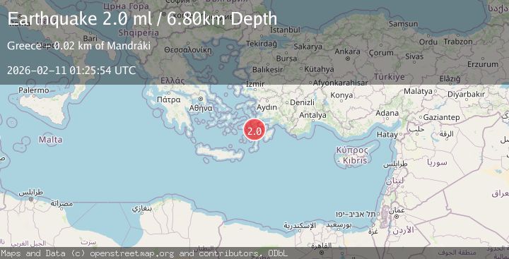
A 2.0 magnitude earthquake struck on DODECANESE IS.-TURKEY BORDER REG, at Wed, 11 Feb 2026 01:25:54 GMT. Depth: 6.8km. Reviewed by KOERI seismologists, this minor quake occurred at a magnitude type of ml.
Magnitude
2.0
ml
Source
KOERI
Intensity
-
Agency Reports
1 Sources| Source | Magnitude | Depth | Time |
|---|---|---|---|
| KOERIPrimary | 2.0 | 7 km | 1 week ago |
Earthquake Details
AutomaticEvent IDemsc_KOERI_20260211_0000030
Tsunami PotentialNo
Magnitude Typeml
Nearest Places
- Kandeliusa Point11.9 km
- Nisída Kandelioússa12.6 km
- Ákra Lefkós12.7 km
- Capo Sant’ Irene12.9 km
- Órmos Lefkós13.0 km
Comments
Join the discussion about this event.
Latest Earthquakes
2.4Mag
West Papua Region, Indonesia
Time12 minutes ago
Depth10.00 km
SourceBMKG
3.3Mag
Talaud Islands, Indonesia
Time13 minutes ago
Depth10.00 km
SourceBMKG
1.1Mag
4 km NW of The Geysers, CA
Time13 minutes ago
Depth3.39 km
SourceUSGS (Automatic)
1.0Mag
33 km WSW of Ackerly, Texas
Time13 minutes ago
Depth4.44 km
SourceUSGS (Automatic)
2.8Mag
Antofagasta, Chile
Time17 minutes ago
Depth0.00 km
SourceVYT (Automatic)
Nearby Earthquakes
3.0Mag
DODECANESE IS.-TURKEY BORDER REG
Time4 years ago
Depth2.00 km
SourceEMSC (Automatic)
4.0Mag
DODECANESE IS.-TURKEY BORDER REG
Time4 years ago
Depth10.00 km
SourceEMSC (Automatic)
3.0Mag
DODECANESE IS.-TURKEY BORDER REG
Time11 years ago
Depth2.00 km
SourceEMSC (Automatic)
3.0Mag
DODECANESE IS.-TURKEY BORDER REG
Time4 years ago
Depth18.00 km
SourceEMSC (Automatic)
3.0Mag
DODECANESE IS.-TURKEY BORDER REG
Time4 years ago
Depth9.00 km
SourceEMSC (Automatic)