Earthquake PERU-ECUADOR BORDER REGION
Sun, 09 Dec 2018 16:27:00 GMT
Time7 years ago
Location
-4.0800, -80.3100
Depth
52.0 KM
Event Summary
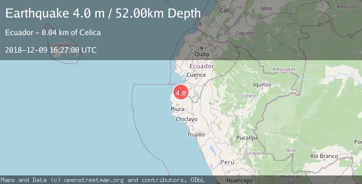
A 4.0 magnitude earthquake struck on PERU-ECUADOR BORDER REGION, at Sun, 09 Dec 2018 16:27:00 GMT. Depth: 52km. Reviewed by LIM seismologists, this light quake occurred at a magnitude type of m.
Magnitude
4.0
m
Source
LIM
Intensity
-
Agency Reports
1 Sources| Source | Magnitude | Depth | Time |
|---|---|---|---|
| LIMPrimary | 4.0 | 52 km | 7 years ago |
Earthquake Details
AutomaticEvent IDemsc_LIM_20181209_0000099
Tsunami PotentialNo
Magnitude Typem
Nearest Places
- Cordillera Mangaurquillo2.1 km
- Cordillera de Guapalal4.2 km
- Cerro Las Patas4.8 km
- Quebrada Leonera5.0 km
- Cerro de La Mesa5.0 km
Comments
Join the discussion about this event.
Latest Earthquakes
2.5Mag
Tarapaca, Chile
Time4 minutes ago
Depth112.55 km
SourceVYT (Automatic)
2.2Mag
Tarapaca, Chile
Time10 minutes ago
Depth111.94 km
SourceVYT (Automatic)
1.9Mag
Central Alaska
Time10 minutes ago
Depth32.10 km
SourceVYT (Automatic)
3.4Mag
HAWAII REGION, HAWAII
Time11 minutes ago
Depth4.70 km
SourceHV (Automatic)
1.9Mag
STRAIT OF GIBRALTAR
Time14 minutes ago
Depth0.00 km
SourceIGN (Automatic)
Nearby Earthquakes
4.0Mag
PERU-ECUADOR BORDER REGION
Time4 months ago
Depth81.00 km
SourceLIM (Automatic)
5.3Mag
PERU-ECUADOR BORDER REGION
Time5 years ago
Depth72.00 km
SourceEMSC (Automatic)
5.6Mag
PERU-ECUADOR BORDER REGION
Time8 years ago
Depth60.00 km
SourceEMSC (Automatic)
4.0Mag
PERU-ECUADOR BORDER REGION
Time3 years ago
Depth66.00 km
SourceLIM (Automatic)
4.0Mag
PERU-ECUADOR BORDER REGION
Time3 years ago
Depth48.00 km
SourceNEIC (Automatic)