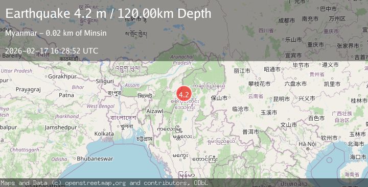
Earthquake MYANMAR
Tue, 17 Feb 2026 16:28:52 GMT
Time3 days ago
Location
25.4400, 95.2600
Depth
120.0 KM
Event Summary
A 4.2 magnitude earthquake struck on MYANMAR, at Tue, 17 Feb 2026 16:28:52 GMT. Depth: 120km. Reviewed by NDI seismologists, this light quake occurred at a magnitude type of m.
Magnitude
4.2
m
Source
NDI
Intensity
-
Agency Reports
1 Sources| Source | Magnitude | Depth | Time |
|---|---|---|---|
| NDIPrimary | 4.2 | 120 km | 3 days ago |
Earthquake Details
AutomaticEvent IDemsc_NDI_20260217_0000244
Tsunami PotentialNo
Magnitude Typem
Nearest Places
- 4.8 km
- 6.3 km
- 6.4 km
- 7.8 km
- 8.8 km
Comments
Join the discussion about this event.
Latest Earthquakes
2.0Mag
Poland
Time3 minutes ago
Depth5.62 km
SourceVYT (Automatic)
1.4Mag
3 km WSW of Mira Loma, CA
Time3 minutes ago
Depth7.18 km
SourceUSGS (Automatic)
2.6Mag
Southern Alaska
Time11 minutes ago
Depth42.60 km
SourceVYT (Automatic)
1.8Mag
STRAIT OF GIBRALTAR
Time11 minutes ago
Depth2.30 km
SourceIGN (Automatic)
2.8Mag
south of Java, Indonesia
Time12 minutes ago
Depth0.00 km
SourceVYT (Automatic)
Nearby Earthquakes
5.1Mag
MYANMAR
Time16 years ago
Depth77.00 km
SourceEMSC (Automatic)
6.0Mag
MYANMAR
Time13 years ago
Depth99.00 km
SourceEMSC (Automatic)
3.0Mag
MYANMAR-INDIA BORDER REGION
Time6 months ago
Depth120.00 km
SourceNDI (Automatic)
4.0Mag
MYANMAR-INDIA BORDER REGION
Time4 years ago
Depth97.00 km
SourceNDI (Automatic)
5.3Mag
MYANMAR-INDIA BORDER REGION
Time20 years ago
Depth80.00 km
SourceEMSC (Automatic)