Earthquake SOUTH OF ALASKA
Mon, 16 Feb 2026 04:31:49 GMT
Time2 days ago
Location
54.7396, -156.6082
Depth
10.0 KM
Event Summary
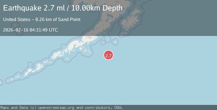
A 2.7 magnitude earthquake struck on SOUTH OF ALASKA, at Mon, 16 Feb 2026 04:31:49 GMT. Depth: 10km. Reviewed by NEIC seismologists, this minor quake occurred at a magnitude type of ml.
Magnitude
2.7
ml
Source
NEIC
Intensity
-
Agency Reports
1 Sources| Source | Magnitude | Depth | Time |
|---|---|---|---|
| NEICPrimary | 2.7 | 10 km | 2 days ago |
Earthquake Details
AutomaticEvent IDemsc_NEIC_20260216_0000365
Tsunami PotentialNo
Magnitude Typeml
Nearest Places
- Walls Knoll113.4 km
- Lighthouse Rocks126.2 km
- South Cape129.5 km
- Southwest Anchorage131.3 km
- Round Rock131.5 km
Comments
Join the discussion about this event.
Latest Earthquakes
2.6Mag
Central Alaska
Time21 hours ago
Depth0.00 km
SourceVYT (Automatic)
3.9Mag
Ceram Sea
Time21 hours ago
Depth10.40 km
SourceBMKG
2.2Mag
Central Alaska
Time21 hours ago
Depth35.40 km
SourceVYT (Automatic)
1.1Mag
3 km W of Cobb, CA
Time21 hours ago
Depth1.93 km
SourceUSGS (Automatic)
1.6Mag
14 km W of Johannesburg, CA
Time22 hours ago
Depth2.16 km
SourceUSGS (Automatic)
Nearby Earthquakes
4.0Mag
SOUTH OF ALASKA
Time1 year ago
Depth10.00 km
SourceEMSC (Automatic)
3.0Mag
SOUTH OF ALASKA
Time2 years ago
Depth5.00 km
SourceNEIR (Automatic)
3.0Mag
SOUTH OF ALASKA
Time6 months ago
Depth25.00 km
SourceAK (Automatic)
3.0Mag
SOUTH OF ALASKA
Time2 years ago
Depth26.40 km
SourceAK (Automatic)
3.0Mag
SOUTH OF ALASKA
Time6 years ago
Depth33.00 km
SourceNEIR (Automatic)