Earthquake SOUTHEASTERN ALASKA
Fri, 03 Feb 2017 11:02:03 GMT
Time9 years ago
Location
58.8600, -136.2900
Depth
6.0 KM
Event Summary
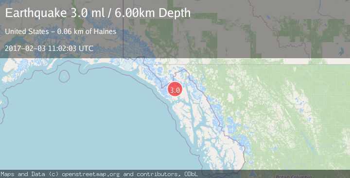
A 3.0 magnitude earthquake struck on SOUTHEASTERN ALASKA, at Fri, 03 Feb 2017 11:02:03 GMT. Depth: 6km. Reviewed by NEIR seismologists, this minor quake occurred at a magnitude type of ml.
Magnitude
3.0
ml
Source
NEIR
Intensity
-
Agency Reports
1 Sources| Source | Magnitude | Depth | Time |
|---|---|---|---|
| NEIRPrimary | 3.0 | 6 km | 9 years ago |
Earthquake Details
AutomaticEvent IDemsc_NEIR_20170203_0000062
Tsunami PotentialNo
Magnitude Typeml
Nearest Places
- Oberlin Ridge0.9 km
- Morse Glacier1.2 km
- Pyramid Peak1.7 km
- Mount Kloh Kutz3.2 km
- Dying Glacier (historical)3.9 km
Comments
Join the discussion about this event.
Latest Earthquakes
4.5Mag
Tarapaca, Chile
Time4 minutes ago
Depth128.42 km
SourceVYT (Automatic)
1.5Mag
4 km NE of Muscoy, CA
Time10 minutes ago
Depth7.69 km
SourceUSGS (Automatic)
0.8Mag
6 km W of Cobb, CA
Time11 minutes ago
Depth0.90 km
SourceUSGS (Automatic)
1.4Mag
Southern Alaska
Time16 minutes ago
Depth70.19 km
SourceVYT (Automatic)
1.3Mag
14 km SW of Toms Place, CA
Time17 minutes ago
Depth5.49 km
SourceUSGS (Automatic)
Nearby Earthquakes
3.0Mag
SOUTHEASTERN ALASKA
Time8 years ago
Depth8.00 km
SourceNEIR (Automatic)
3.0Mag
SOUTHEASTERN ALASKA
Time5 years ago
Depth16.00 km
SourceNEIR (Automatic)
3.0Mag
SOUTHEASTERN ALASKA
Time2 years ago
Depth6.70 km
SourceAK (Automatic)
2.5Mag
SOUTHEASTERN ALASKA
Time3 weeks ago
Depth1.00 km
SourceCN (Automatic)
5.2Mag
SOUTHEASTERN ALASKA
Time2 years ago
Depth3.90 km
SourceEMSC (Automatic)