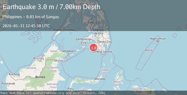
Earthquake MORO GULF, MINDANAO, PHILIPPINES
Sat, 31 Jan 2026 12:45:38 GMT
Time2 weeks ago
Location
6.4300, 123.7700
Depth
7.0 KM
Event Summary
A 3.0 magnitude earthquake struck on MORO GULF, MINDANAO, PHILIPPINES, at Sat, 31 Jan 2026 12:45:38 GMT. Depth: 7km. Reviewed by PIVS seismologists, this minor quake occurred at a magnitude type of m.
Magnitude
3.0
m
Source
PIVS
Intensity
-
Agency Reports
1 Sources| Source | Magnitude | Depth | Time |
|---|---|---|---|
| PIVSPrimary | 3.0 | 7 km | 2 weeks ago |
Earthquake Details
AutomaticEvent IDemsc_PIVS_20260131_0000194
Tsunami PotentialNo
Magnitude Typem
Nearest Places
- Donaung Shoals26.1 km
- Donauang Island28.1 km
- Basiauang Bay28.9 km
- Danawan Point28.9 km
- Basiauang Point29.2 km
Comments
Join the discussion about this event.
Latest Earthquakes
2.1Mag
Sweden
Time2 hours ago
Depth0.12 km
SourceVYT (Automatic)
2.1Mag
near the coast of Tarapaca, Chile
Time3 hours ago
Depth74.46 km
SourceVYT (Automatic)
0.9Mag
8 km WNW of Cobb, CA
Time3 hours ago
Depth1.98 km
SourceUSGS (Automatic)
1.4Mag
9 km SW of Idyllwild, CA
Time3 hours ago
Depth17.57 km
SourceUSGS (Automatic)
0.8Mag
9 km NW of The Geysers, CA
Time3 hours ago
Depth1.76 km
SourceUSGS (Automatic)
Nearby Earthquakes
5.0Mag
Mindanao, Philippines
Time3 weeks ago
Depth10.00 km
SourceBMKG (Automatic)
3.0Mag
MORO GULF, MINDANAO, PHILIPPINES
Time3 weeks ago
Depth23.00 km
SourcePIVS (Automatic)
3.7Mag
MORO GULF, MINDANAO, PHILIPPINES
Time2 weeks ago
Depth5.00 km
SourcePIVS (Automatic)
4.2Mag
MORO GULF, MINDANAO, PHILIPPINES
Time0 months ago
Depth10.00 km
SourcePIVS (Automatic)
3.1Mag
MORO GULF, MINDANAO, PHILIPPINES
Time1 week ago
Depth19.00 km
SourcePIVS (Automatic)