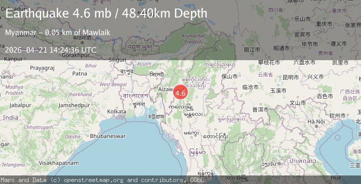
Earthquake MYANMAR-INDIA BORDER REGION
Tue, 21 Apr 2026 14:24:36 GMT
Time1 week ago
Location
23.8160, 93.9960
Depth
48.4 KM
Event Summary
A 4.6 magnitude earthquake struck on MYANMAR-INDIA BORDER REGION, at Tue, 21 Apr 2026 14:24:36 GMT. Depth: 48.4km. Reviewed by GFZ seismologists, this light quake occurred at a magnitude type of mb.
Magnitude
4.6
mb
Source
GFZ
Intensity
III
Agency Reports
3 Sources| Source | Magnitude | Depth | Time |
|---|---|---|---|
| GFZPrimary | 4.6 | 48 km | 1 week ago |
| NEIC | 4.5 | 78 km | 1 week ago |
| EMSC | 4.5 | 66 km | 1 week ago |
Earthquake Details
AutomaticEvent IDemsc_gfz_20260421_0000284
QualityS
Tsunami PotentialNo
Magnitude Typemb
Last Update1 week ago
Nearest Places
Possibly felt by: 215.8K
- IIIMawlaik45.9 km44.5K people
- IIIChandel57.1 km
- IIITengnoupal65.2 km
- 66.4 km47.8K people
- IIKakching75.9 km30.4K people
- IIMoirāng78.9 km17.1K people
- IIWāngjing86.3 km7.5K people
- IIKhawzawl88.6 km
- 89.0 km22.2K people
- IIThoubāl91.5 km44.5K people
- 93.4 km
- IIPherzawl95.8 km
- IIYairipok96.0 km8.8K people
- IIKhawhai101.0 km2.5K people
- IIFalam105.5 km5.4K people
- IISaitual105.8 km
- IIImphāl110.4 km223.5K people
- IIDarlawn111.1 km4K people
- 121.6 km3.5K people
- IIKamjong127.3 km
- IIAizawl130.4 km265.3K people
- IISerchhīp130.8 km20.2K people
- IIHakha136.1 km20K people
- IISairang136.7 km5.8K people
- 138.6 km6K people
- 141.2 km
- 141.3 km25K people
- 144.1 km
- 145.6 km11K people
- 147.7 km12.9K people
- 148.7 km
- 153.7 km6.1K people
- 161.4 km
- ILāla162.3 km10.9K people
- 164.1 km52.7K people
- 165.5 km152.4K people
- 174.6 km31K people
- 176.3 km7.2K people
- 179.7 km40K people
- 180.1 km22.7K people
- 183.9 km11K people
- 186.6 km8.4K people
- 195.5 km32.9K people
- 203.3 km55.3K people
- 207.0 km92.1K people
- 210.2 km22.1K people
- IPhek212.0 km15.1K people
- 218.2 km6.4K people
- 221.1 km50.4K people
- 222.4 km88.9K people
- 222.8 km182K people
- 223.6 km5.5K people
- 230.6 km25.3K people
Felt Reports0
Did you feel this earthquake? Report it to help others.
No reports yet
Be the first to report this earthquake!
Latest Earthquakes
Loading...
Nearby Earthquakes
3.0Mag
MYANMAR
Time2 days ago
Depth80.00 km
SourceNDI (Automatic)
3.4Mag
Myanmar-India border region
Time5 days ago
Depth10.00 km
SourceVYT (Automatic)
3.3Mag
MYANMAR-INDIA BORDER REGION
Time1 week ago
Depth68.00 km
SourceNDI (Automatic)
3.8Mag
MYANMAR
Time1 week ago
Depth117.00 km
SourceNDI (Automatic)
3.6Mag
MANIPUR, INDIA REGION
Time2 weeks ago
Depth50.00 km
SourceNDI (Automatic)