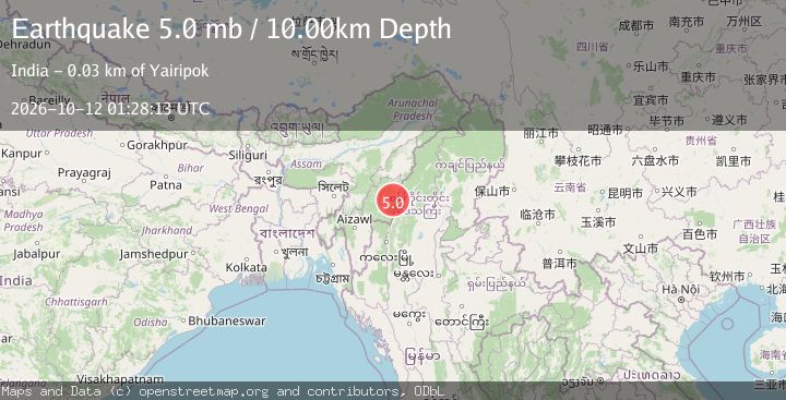
Earthquake MYANMAR-INDIA BORDER REGION
Mon, 12 Oct 2026 01:28:13 GMT
Time2 weeks ago
Location
24.7620, 94.2790
Depth
10.0 KM
Event Summary
A 5.0 magnitude earthquake struck on MYANMAR-INDIA BORDER REGION, at Mon, 12 Oct 2026 01:28:13 GMT. Depth: 10km. Reviewed by GFZ seismologists, this moderate quake occurred at a magnitude type of mb.
Magnitude
5.0
mb
Source
GFZ
Intensity
V
Agency Reports
4 Sources| Source | Magnitude | Depth | Time |
|---|---|---|---|
| GFZPrimary | 5.0 | 10 km | 2 weeks ago |
| EMSC | 4.8 | 84 km | 2 weeks ago+7s |
| NEIC | 4.8 | 78 km | 2 weeks ago+7s |
| USGS | 4.8 | 78 km | 2 weeks ago+7s |
Earthquake Details
AutomaticEvent IDemsc_gfz_20261012_0000025
QualityS
Tsunami PotentialNo
Magnitude Typemb
Last Update2 weeks ago
Used Stations65
Nearest Places
Possibly felt by: 563.7K
- 25.2 km8.8K people
- 26.2 km
- 29.0 km7.5K people
- IVThoubāl31.7 km44.5K people
- IVImphāl34.2 km223.5K people
- IVKakching42.0 km30.4K people
- 42.9 km22.2K people
- 43.9 km
- 53.4 km
- 54.3 km
- IVChandel55.5 km
- IIIMoirāng58.6 km17.1K people
- 77.9 km47.8K people
- IIIKohīma102.9 km92.1K people
- IIIPhek103.0 km15.1K people
- IIJiribam117.0 km
- IIPherzawl123.5 km
- IIMawlaik125.1 km44.5K people
- IIMahur126.5 km7.2K people
- IILakhipur128.3 km12.9K people
- IIMaibong129.6 km8.4K people
- IIHāflong134.8 km40K people
- 136.1 km29.5K people
- IIDimāpur139.6 km135.9K people
- IIDiphu147.4 km57.1K people
- IIWokha148.5 km54K people
- IIBokajān148.8 km16.6K people
- IISilchar149.7 km152.4K people
- 156.5 km25.3K people
- IIDarlawn160.5 km4K people
- IILāla169.6 km10.9K people
- IIBadarpur170.3 km11K people
- IIKolasib172.6 km25K people
- 173.7 km31K people
- 174.1 km7.4K people
- 175.4 km34K people
- IITuensang176.1 km33.7K people
- IIKhawzawl177.1 km
- IISaitual179.1 km
- 193.2 km2.5K people
- 193.7 km11K people
- 194.5 km55.3K people
- 195.6 km265.3K people
- 195.9 km5.8K people
- 197.2 km34.4K people
- 198.7 km36.9K people
- 199.6 km
- 203.7 km6.1K people
- 203.7 km
- 204.7 km7.8K people
- 210.8 km23.6K people
- 211.8 km
- 214.3 km7.4K people
- 214.5 km5.4K people
- 217.8 km13.4K people
- 218.1 km32.9K people
- 218.7 km20.2K people
- 219.2 km3.5K people
- 219.6 km9.6K people
- 222.0 km69K people
- 223.5 km6K people
- 229.6 km8.5K people
- IMon232.9 km18.7K people
- 235.0 km22.1K people
- IRahā240.9 km4.7K people
- 242.3 km
- 243.4 km237K people
- 243.4 km
- 243.9 km14.3K people
- 244.9 km9.9K people
- 245.1 km20K people
- 246.1 km
- 249.7 km62.1K people
- 253.4 km11.8K people
- 254.8 km20.8K people
- 255.3 km5.5K people
- 255.3 km57.4K people
- 255.4 km58.9K people
- 257.3 km132.8K people
- 257.4 km
- 260.1 km52.7K people
- 262.2 km19.7K people
- 262.2 km20.8K people
- 262.2 km6.4K people
- 265.0 km39.2K people
- 265.5 km3K people
- 266.9 km26.9K people
- 267.0 km11.1K people
- 267.0 km45K people
- 267.7 km
- 272.7 km14.4K people
- 275.6 km59.8K people
- 277.1 km7.1K people
- 280.5 km12.6K people
- 281.3 km21.3K people
- 281.5 km18.7K people
- 281.7 km20K people
- 281.9 km10.2K people
- 283.4 km88.9K people
- 284.5 km
- 284.9 km22.7K people
Felt Reports0
Did you feel this earthquake? Report it to help others.
No reports yet
Be the first to report this earthquake!
Latest Earthquakes
Loading...
Nearby Earthquakes
3.9Mag
MYANMAR-INDIA BORDER REGION
Time2 days ago
Depth115.00 km
SourceNDI (Automatic)
3.3Mag
MYANMAR-INDIA BORDER REGION
Time5 days ago
Depth13.00 km
SourceNDI (Automatic)
3.5Mag
MYANMAR-INDIA BORDER REGION
Time5 days ago
Depth99.00 km
SourceNDI (Automatic)
3.4Mag
MYANMAR-INDIA BORDER REGION
Time1 week ago
Depth55.00 km
SourceNDI (Automatic)
3.1Mag
MYANMAR-INDIA BORDER REGION
Time1 week ago
Depth40.00 km
SourceNDI (Automatic)