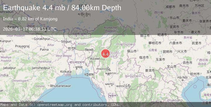
Earthquake MYANMAR-INDIA BORDER REGION
Tue, 17 Mar 2026 06:38:51 GMT
Time1 week ago
Location
24.8600, 94.1800
Depth
45.0 KM
Event Summary
A 4.3 magnitude earthquake struck on MYANMAR-INDIA BORDER REGION, at Tue, 17 Mar 2026 06:38:51 GMT. Depth: 45km. Reviewed by NDI seismologists, this light quake occurred at a magnitude type of m.
Magnitude
4.3
m
Source
NDI
Intensity
III
Agency Reports
3 Sources| Source | Magnitude | Depth | Time |
|---|---|---|---|
| NDIPrimary | 4.3 | 45 km | 1 week ago |
| USGS | 4.4 | 94 km | 1 week ago |
| EMSC | 4.4 | 84 km | 1 week ago |
Earthquake Details
AutomaticEvent IDemsc_ndi_20260317_0000094
QualityS
Tsunami PotentialNo
Magnitude Typem
Last Update1 week ago
Nearest Places
Possibly felt by: 204.9K
- IIIYairipok24.3 km8.8K people
- IIIImphāl24.5 km223.5K people
- IIIThoubāl30.8 km44.5K people
- IIIWāngjing32.3 km7.5K people
- IIIKamjong33.9 km
- IIIKāngpokpi38.7 km
- 40.5 km22.2K people
- IIIKakching45.0 km30.4K people
- 49.5 km
- 52.9 km
- IIMoirāng57.2 km17.1K people
- IIChandel61.6 km
- 78.0 km47.8K people
- IIKohīma90.8 km92.1K people
- IIPhek95.3 km15.1K people
Felt Reports0
Did you feel this earthquake? Report it to help others.
No reports yet
Be the first to report this earthquake!
Latest Earthquakes
Loading...
Nearby Earthquakes
4.3Mag
MYANMAR
Time1 day ago
Depth110.00 km
SourceNDI (Automatic)
3.8Mag
MYANMAR-INDIA BORDER REGION
Time1 week ago
Depth50.00 km
SourceNDI (Automatic)
3.5Mag
MANIPUR, INDIA REGION
Time2 weeks ago
Depth60.00 km
SourceNDI (Automatic)
4.5Mag
MYANMAR
Time2 weeks ago
Depth85.30 km
SourceGFZ (Automatic)
3.1Mag
MANIPUR, INDIA REGION
Time2 weeks ago
Depth37.00 km
SourceNDI (Automatic)