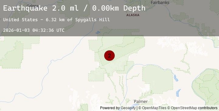
Earthquake 47 km SSE of Denali National Park, Alaska
Sat, 03 Jan 2026 04:32:36 GMT
Time8 hours ago
Location
63.1450, -151.3650
Depth
0.0 KM
Event Summary
A 2.0 magnitude earthquake struck on 47 km SSE of Denali National Park, Alaska, at Sat, 03 Jan 2026 04:32:36 GMT. Depth: 0km. Reviewed by USGS seismologists, this minor quake occurred at a magnitude type of ml.
Magnitude
2.0
ml
Source
USGS
Intensity
-
Agency Reports
1 Sources| Source | Magnitude | Depth | Time |
|---|---|---|---|
| USGSPrimary | 2.0 | 0 km | 8 hours ago |
Earthquake Details
AutomaticEvent IDusgs_ak2026aeamrl
Tsunami PotentialNo
Magnitude Typeml
Nearest Places
- Spygalls Hill6.3 km
- Peters Dome8.2 km
- Peters Pass8.4 km
- Peters Basin10.1 km
- Foraker Galcier11.1 km
Comments
Join the discussion about this event.
Latest Earthquakes
2.3Mag
Java, Indonesia
Time8 hours ago
Depth31.16 km
SourceBMKG (Automatic)
3.1Mag
Borneo
Time8 hours ago
Depth3.17 km
SourceBMKG (Automatic)
2.7Mag
Borneo
Time8 hours ago
Depth3.82 km
SourceBMKG (Automatic)
1.8Mag
7 km W of Beluga, Alaska
Time8 hours ago
Depth68.10 km
SourceUSGS (Automatic)
2.3Mag
Sulawesi, Indonesia
Time8 hours ago
Depth18.90 km
SourceBMKG (Automatic)
Nearby Earthquakes
2.8Mag
45 km SSE of Denali National Park, Alaska
Time14 hours ago
Depth0.00 km
SourceUSGS (Automatic)
2.3Mag
61 km SW of Cantwell, Alaska
Time16 hours ago
Depth83.80 km
SourceUSGS (Automatic)
2.1Mag
46 km W of Cantwell, Alaska
Time17 hours ago
Depth94.50 km
SourceUSGS (Automatic)
1.6Mag
21 km ESE of Denali National Park, Alaska
Time1 day ago
Depth0.10 km
SourceUSGS (Automatic)