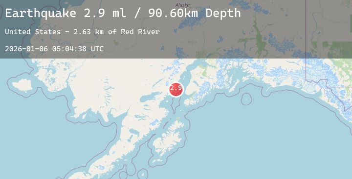
Earthquake 50 km WNW of Anchor Point, Alaska
Tue, 06 Jan 2026 05:04:38 GMT
Time1 day ago
Location
59.9030, -152.6940
Depth
92.4 KM
Event Summary
A 2.4 magnitude earthquake struck on 50 km WNW of Anchor Point, Alaska, at Tue, 06 Jan 2026 05:04:38 GMT. Depth: 92.4km. Reviewed by USGS seismologists, this minor quake occurred at a magnitude type of ml.
Magnitude
2.4
ml
Source
USGS
Intensity
-
Agency Reports
1 Sources| Source | Magnitude | Depth | Time |
|---|---|---|---|
| USGSPrimary | 2.4 | 92 km | 1 day ago |
Earthquake Details
AutomaticEvent IDusgs_ak2026ajosxx
Tsunami PotentialNo
Magnitude Typeml
Nearest Places
- Red River2.6 km
- Herbs Lagoon5.6 km
- Shelter Cove6.3 km
- Shelter Creek6.8 km
- Spring Point6.9 km
Comments
Join the discussion about this event.
Latest Earthquakes
2.6Mag
Timor Region
Time1 day ago
Depth4.01 km
SourceBMKG (Automatic)
3.2Mag
PERU-ECUADOR BORDER REGION
Time1 day ago
Depth94.00 km
SourceQUI (Automatic)
2.3Mag
Sumbawa Region, Indonesia
Time1 day ago
Depth106.47 km
SourceBMKG (Automatic)
3.2Mag
Seram, Indonesia
Time1 day ago
Depth10.00 km
SourceBMKG (Automatic)
4.1Mag
Mindanao, Philippines
Time1 day ago
Depth90.51 km
SourceBMKG (Automatic)