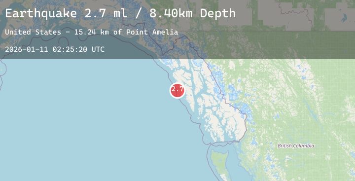
Earthquake 52 km WNW of Sitka, Alaska
Sun, 11 Jan 2026 02:25:20 GMT
Time1 day ago
Location
57.2350, -136.1270
Depth
8.4 KM
Event Summary
A 2.7 magnitude earthquake struck on 52 km WNW of Sitka, Alaska, at Sun, 11 Jan 2026 02:25:20 GMT. Depth: 8.4km. Reviewed by USGS seismologists, this minor quake occurred at a magnitude type of ml.
Magnitude
2.7
ml
Source
USGS
Intensity
-
Agency Reports
1 Sources| Source | Magnitude | Depth | Time |
|---|---|---|---|
| USGSPrimary | 2.7 | 8 km | 1 day ago |
Earthquake Details
AutomaticEvent IDusgs_ak2026asocaz
Tsunami PotentialNo
Magnitude Typeml
Nearest Places
- Point Amelia15.2 km
- Sealion Island15.6 km
- Sealion Islands16.0 km
- Twin Point16.7 km
- Eagle Rock17.1 km
Comments
Join the discussion about this event.
Latest Earthquakes
1.1Mag
10 km NNW of Twentynine Palms, CA
Time1 day ago
Depth10.40 km
SourceUSGS (Automatic)
3.0Mag
WESTERN TURKEY
Time1 day ago
Depth10.40 km
SourceEMSC (Automatic)
2.1Mag
AZORES ISLANDS, PORTUGAL
Time1 day ago
Depth3.30 km
SourceIPMA (Automatic)
1.8Mag
16 km W of Searles Valley, CA
Time1 day ago
Depth3.42 km
SourceUSGS (Automatic)
2.8Mag
Java, Indonesia
Time1 day ago
Depth14.87 km
SourceBMKG (Automatic)
Nearby Earthquakes
No significant earthquakes nearby recently.