Earthquake 58 km SE of Kokhanok, Alaska
Thu, 12 Feb 2026 03:31:41 GMT
Time6 days ago
Location
59.0330, -154.1230
Depth
117.0 KM
Event Summary
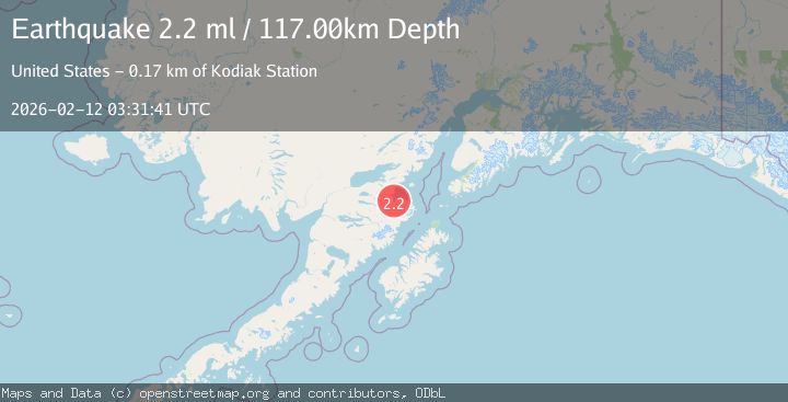
A 2.2 magnitude earthquake struck on 58 km SE of Kokhanok, Alaska, at Thu, 12 Feb 2026 03:31:41 GMT. Depth: 117km. Reviewed by USGS seismologists, this minor quake occurred at a magnitude type of ml.
Magnitude
2.2
ml
Source
USGS
Intensity
-
Agency Reports
1 Sources| Source | Magnitude | Depth | Time |
|---|---|---|---|
| USGSPrimary | 2.2 | 117 km | 6 days ago |
Earthquake Details
AutomaticEvent IDusgs_ak2026czjnjw
Tsunami PotentialNo
Magnitude Typeml
Nearest Places
- Ashivak0.4 km
- Akumwarvik Bay2.6 km
- Kamishak River2.6 km
- Little Kamishak River3.0 km
- Pinkidulia Cove5.5 km
Comments
Join the discussion about this event.
Latest Earthquakes
3.2Mag
AEGEAN SEA
Time4 hours ago
Depth5.00 km
SourceNOA (Automatic)
1.5Mag
7 km NW of The Geysers, CA
Time4 hours ago
Depth2.48 km
SourceUSGS (Automatic)
2.3Mag
WESTERN TURKEY
Time4 hours ago
Depth8.70 km
SourceKOERI (Automatic)
0.6Mag
6 km WNW of Cobb, CA
Time4 hours ago
Depth1.68 km
SourceUSGS (Automatic)
2.1Mag
Southern Alaska
Time4 hours ago
Depth27.59 km
SourceVYT (Automatic)
Nearby Earthquakes
2.2Mag
Southern Alaska
Time6 days ago
Depth110.35 km
SourceVYT (Automatic)
2.9Mag
Alaska Peninsula
Time1 week ago
Depth115.84 km
SourceVYT (Automatic)
1.5Mag
Southern Alaska
Time4 days ago
Depth115.11 km
SourceVYT (Automatic)
5.0Mag
SOUTHERN ALASKA
Time2 years ago
Depth115.60 km
SourceEMSC (Automatic)
3.0Mag
SOUTHERN ALASKA
Time2 years ago
Depth130.00 km
SourceNEIC (Automatic)