Earthquake 44 km NNW of Los Algodones, B.C., MX
Thu, 26 Feb 2026 19:01:14 GMT
Time4 hours ago
Location
33.0388, -114.9865
Depth
3.6 KM
Event Summary
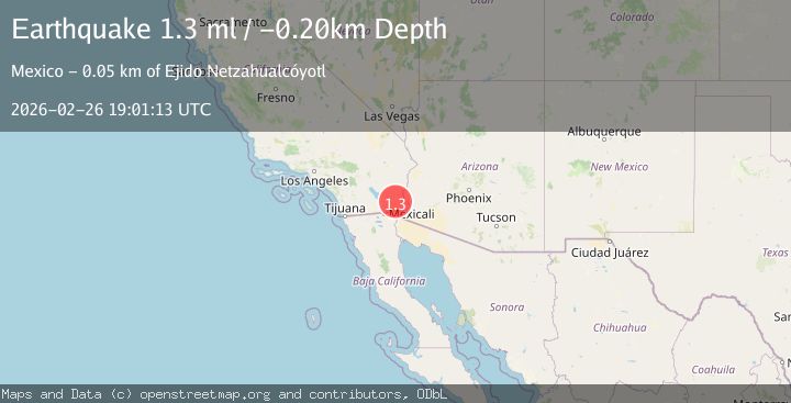
A 1.4 magnitude earthquake struck on 44 km NNW of Los Algodones, B.C., MX, at Thu, 26 Feb 2026 19:01:14 GMT. Depth: 3.65km. Reviewed by USGS seismologists, this minor quake occurred at a magnitude type of ml.
Magnitude
1.4
ml
Source
USGS
Intensity
-
Agency Reports
1 Sources| Source | Magnitude | Depth | Time |
|---|---|---|---|
| USGSPrimary | 1.4 | 4 km | 4 hours ago |
Earthquake Details
AutomaticEvent IDusgs_ci41404552
Tsunami PotentialNo
Magnitude Typeml
Nearest Places
- 0.8 km
- 1.5 km
- 2.5 km
- 3.5 km
- 5.2 km
Comments
Join the discussion about this event.
Latest Earthquakes
3.1Mag
Halmahera, Indonesia
Time4 hours ago
Depth128.66 km
SourceVYT (Automatic)
2.3Mag
Region Metropolitana, Chile
Time4 hours ago
Depth17.70 km
SourceVYT (Automatic)
2.3Mag
Minahassa Peninsula, Sulawesi
Time4 hours ago
Depth29.63 km
SourceBMKG
1.7Mag
13 km WNW of Kalaoa, Hawaii
Time4 hours ago
Depth8.44 km
SourceUSGS (Automatic)
2.9Mag
Fox Islands, Aleutian Islands, Alaska
Time4 hours ago
Depth39.67 km
SourceVYT (Automatic)
Nearby Earthquakes
2.0Mag
Southern California
Time2 days ago
Depth0.00 km
SourceVYT (Automatic)
2.1Mag
Southern California
Time2 weeks ago
Depth14.53 km
SourceVYT (Automatic)
2.9Mag
California-Baja California border region
Time1 week ago
Depth21.73 km
SourceVYT (Automatic)
1.6Mag
Southern California
Time1 week ago
Depth4.64 km
SourceVYT (Automatic)
2.1Mag
Southern California
Time2 weeks ago
Depth0.00 km
SourceVYT (Automatic)