Earthquake California-Baja California border region
Mon, 16 Feb 2026 10:21:14 GMT
Time1 week ago
Location
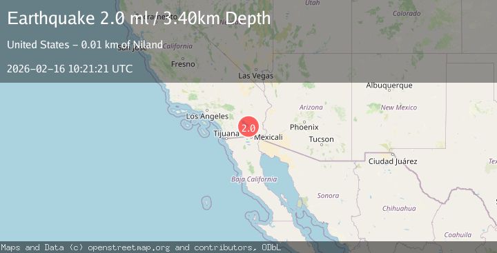
32.8640, -115.1356
Depth
21.7 KM
Event Summary
A 2.9 magnitude earthquake struck on California-Baja California border region, at Mon, 16 Feb 2026 10:21:14 GMT. Depth: 21.728515625km. Reviewed by VYT seismologists, this minor quake occurred at a magnitude type of earthquake.
Magnitude
2.9
earthquake
Source
VYT
Intensity
-
Agency Reports
3 Sources| Source | Magnitude | Depth | Time |
|---|---|---|---|
| VYTPrimary | 2.9 | 22 km | 1 week ago |
| USGS | 2.0 | 3 km | 1 week ago |
| SCSN | 2.0 | 3 km | 1 week ago |
Earthquake Details
AutomaticEvent IDvyt_27kp7ami77714
Tsunami PotentialNo
Magnitude Typeearthquake
Nearest Places
- 3.8 km
- 4.0 km
- 10.4 km
- 11.5 km
- 12.4 km
Comments
Join the discussion about this event.
Latest Earthquakes
1.3Mag
Southern Alaska
Time17 hours ago
Depth11.23 km
SourceVYT (Automatic)
1.5Mag
Tarapaca, Chile
Time18 hours ago
Depth0.00 km
SourceVYT (Automatic)
2.1Mag
Fox Islands, Aleutian Islands, Alaska
Time18 hours ago
Depth0.00 km
SourceVYT (Automatic)
2.2Mag
Central Alaska
Time18 hours ago
Depth3.91 km
SourceVYT (Automatic)
0.6Mag
8 km SW of Anza, CA
Time18 hours ago
Depth3.50 km
SourceUSGS (Automatic)
Nearby Earthquakes
3.1Mag
California-Baja California border region
Time1 week ago
Depth18.07 km
SourceVYT (Automatic)
1.4Mag
7 km SW of Holtville, CA
Time1 month ago
Depth12.18 km
SourceUSGS (Automatic)
1.5Mag
6 km W of Holtville, CA
Time3 weeks ago
Depth8.56 km
SourceUSGS (Automatic)
1.6Mag
Southern California
Time1 week ago
Depth4.64 km
SourceVYT (Automatic)
2.3Mag
SOUTHERN CALIFORNIA
Time1 month ago
Depth12.10 km
SourceSCSN (Automatic)