Earthquake 12 km E of Pāhala, Hawaii
Mon, 29 Dec 2025 15:45:55 GMT
Time5 hours ago
Location
19.1873, -155.3637
Depth
4.0 KM
Event Summary
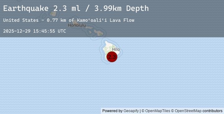
A 2.3 magnitude earthquake struck on 12 km E of Pāhala, Hawaii, at Mon, 29 Dec 2025 15:45:55 GMT. Depth: 3.99000000953674km. Reviewed by USGS seismologists, this minor quake occurred at a magnitude type of ml.
Magnitude
2.3
ml
Source
USGS
Intensity
-
Earthquake Details
AutomaticEvent IDusgs_hv74864167
Tsunami PotentialNo
Magnitude Typeml
Nearest Places
- Papalehau Point1.7 km
- Waiwelawela Point2.9 km
- Kū‘ē‘ē Ruins2.9 km
- Laahana3.5 km
- Nali‘ikakani Point3.5 km
Comments
Join the discussion about this event.
Latest Earthquakes
3.0Mag
OFFSHORE GUATEMALA
Time29 minutes ago
Depth23.00 km
SourceEMSC (Automatic)
2.0Mag
Flores Region, Indonesia
Time29 minutes ago
Depth169.25 km
SourceBMKG (Automatic)
1.6Mag
EASTERN TURKEY
Time32 minutes ago
Depth12.70 km
SourceEMSC (Automatic)
3.7Mag
North of Halmahera, Indonesia
Time32 minutes ago
Depth154.91 km
SourceBMKG (Automatic)
3.7Mag
NORTH OF HALMAHERA, INDONESIA
Time32 minutes ago
Depth155.00 km
SourceEMSC (Automatic)
Nearby Earthquakes
2.3Mag
19 km SE of Pāhala, Hawaii
Time1 hour ago
Depth31.06 km
SourceUSGS (Automatic)
2.4Mag
ISLAND OF HAWAII, HAWAII
Time1 hour ago
Depth38.50 km
SourceEMSC (Automatic)
1.7Mag
14 km E of Pāhala, Hawaii
Time2 hours ago
Depth44.42 km
SourceUSGS (Automatic)
1.8Mag
13 km SE of Pāhala, Hawaii
Time3 hours ago
Depth29.44 km
SourceUSGS (Automatic)
2.2Mag
ISLAND OF HAWAII, HAWAII
Time5 hours ago
Depth28.50 km
SourceEMSC (Automatic)