Earthquake 2 km SE of Tecopa, California
Tue, 03 Mar 2026 17:49:45 GMT
Time1 hour ago
Location
35.8290, -116.2044
Depth
9.6 KM
Event Summary
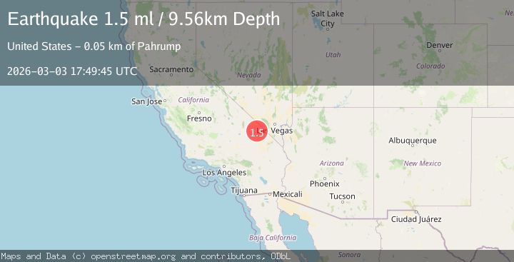
A 1.5 magnitude earthquake struck on 2 km SE of Tecopa, California, at Tue, 03 Mar 2026 17:49:45 GMT. Depth: 9.5552km. Reviewed by USGS seismologists, this minor quake occurred at a magnitude type of ml.
Magnitude
1.5
ml
Source
USGS
Intensity
-
Agency Reports
1 Sources| Source | Magnitude | Depth | Time |
|---|---|---|---|
| USGSPrimary | 1.5 | 10 km | 1 hour ago |
Earthquake Details
AutomaticEvent IDusgs_nn00911707
Tsunami PotentialNo
Magnitude Typeml
Nearest Places
- 1.8 km
- 1.9 km
- 1.9 km
- 2.8 km
- 2.9 km
Comments
Join the discussion about this event.
Latest Earthquakes
2.0Mag
Alaska Peninsula
Time1 hour ago
Depth0.00 km
SourceVYT (Automatic)
3.6Mag
EASTERN KASHMIR
Time1 hour ago
Depth3.30 km
SourceNDI (Automatic)
3.4Mag
Tarapaca, Chile
Time1 hour ago
Depth111.57 km
SourceVYT (Automatic)
2.8Mag
Savu Sea
Time1 hour ago
Depth29.40 km
SourceBMKG
2.4Mag
Washington
Time1 hour ago
Depth2.81 km
SourceVYT (Automatic)
Nearby Earthquakes
2.8Mag
SOUTHERN CALIFORNIA
Time1 month ago
Depth16.00 km
SourceNN (Automatic)
2.1Mag
Southern California
Time1 week ago
Depth8.54 km
SourceVYT (Automatic)
3.0Mag
SOUTHERN CALIFORNIA
Time9 years ago
Depth3.00 km
SourceNEIC (Automatic)
3.0Mag
SOUTHERN CALIFORNIA
Time11 years ago
Depth4.00 km
SourceNEIR (Automatic)
1.8Mag
Central California
Time1 week ago
Depth5.00 km
SourceVYT (Automatic)