Earthquake 12 km SW of Falls City, Texas
Tue, 28 Apr 2026 06:58:42 GMT
Time2 days ago
Location
28.9170, -98.1190
Depth
4.9 KM
Event Summary
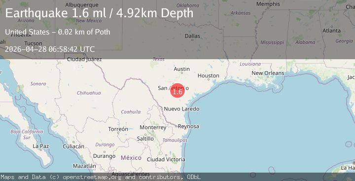
A 1.6 magnitude earthquake struck on 12 km SW of Falls City, Texas, at Tue, 28 Apr 2026 06:58:42 GMT. Depth: 4.9233km. Reviewed by USGS seismologists, this minor quake occurred at a magnitude type of ml.
Magnitude
1.6
ml
Source
USGS
Intensity
-
Agency Reports
1 Sources| Source | Magnitude | Depth | Time |
|---|---|---|---|
| USGSPrimary | 1.6 | 5 km | 2 days ago |
Earthquake Details
AutomaticEvent IDusgs_tx2026ihhvur
QualityS
Tsunami PotentialNo
Magnitude Typeml
Last Update2 days ago
Used Stations6
Felt Reports0
Did you feel this earthquake? Report it to help others.
No reports yet
Be the first to report this earthquake!
Latest Earthquakes
Loading...
Nearby Earthquakes
2.1Mag
SOUTHERN TEXAS
Time52 minutes ago
Depth6.30 km
SourceTX (Automatic)
2.2Mag
SOUTHERN TEXAS
Time11 hours ago
Depth5.20 km
SourceTX (Automatic)
1.6Mag
5 km ENE of Falls City, Texas
Time11 hours ago
Depth8.09 km
SourceUSGS (Automatic)
2.0Mag
SOUTHERN TEXAS
Time14 hours ago
Depth6.70 km
SourceTX (Automatic)
1.6Mag
1 km ESE of Pearsall, Texas
Time16 hours ago
Depth5.06 km
SourceUSGS (Automatic)