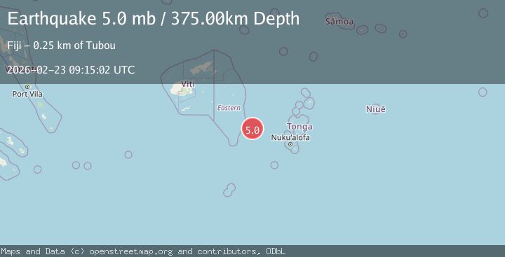
Earthquake 267 km WNW of Houma, Tonga
Mon, 23 Feb 2026 09:15:04 GMT
Time1 hour ago
Location
-20.1016, -177.6036
Depth
393.6 KM
Event Summary
A 5.0 magnitude earthquake struck on 267 km WNW of Houma, Tonga, at Mon, 23 Feb 2026 09:15:04 GMT. Depth: 393.607km. Reviewed by USGS seismologists, this moderate quake occurred at a magnitude type of mb.
Magnitude
5.0
mb
Source
USGS
Intensity
-
Agency Reports
1 Sources| Source | Magnitude | Depth | Time |
|---|---|---|---|
| USGSPrimary | 5.0 | 394 km | 1 hour ago |
Earthquake Details
ConfirmedEvent IDusgs_us6000sb07
Tsunami PotentialNo
Magnitude Typemb
Nearest Places
- 64.0 km
- 73.0 km
- 73.9 km
- 74.3 km
- 74.5 km
Comments
Join the discussion about this event.
Latest Earthquakes
1.9Mag
western Texas
Time1 hour ago
Depth0.00 km
SourceVYT (Automatic)
3.8Mag
Flores region, Indonesia
Time1 hour ago
Depth285.03 km
SourceVYT (Automatic)
2.1Mag
Finland-Russia border region
Time1 hour ago
Depth6.47 km
SourceVYT (Automatic)
1.4Mag
Western Australia
Time1 hour ago
Depth5.98 km
SourceVYT (Automatic)
2.0Mag
Southeastern Alaska
Time1 hour ago
Depth1.34 km
SourceVYT (Automatic)
Nearby Earthquakes
4.0Mag
FIJI REGION
Time1 year ago
Depth504.80 km
SourceNEIC (Automatic)
5.3Mag
FIJI REGION
Time11 years ago
Depth553.00 km
SourceEMSC (Automatic)
4.4Mag
FIJI REGION
Time1 month ago
Depth514.70 km
SourceNEIC (Automatic)
5.8Mag
FIJI REGION
Time4 years ago
Depth494.00 km
SourceEMSC (Automatic)
5.1Mag
FIJI REGION
Time4 years ago
Depth400.00 km
SourceEMSC (Automatic)