Earthquake 174 km ESE of Kokopo, Papua New Guinea
Mon, 13 Apr 2026 02:56:01 GMT
Time2 weeks ago
Location
-5.1908, 153.5930
Depth
68.0 KM
Event Summary
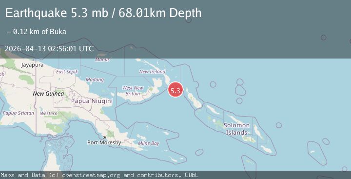
A 5.3 magnitude earthquake struck on 174 km ESE of Kokopo, Papua New Guinea, at Mon, 13 Apr 2026 02:56:01 GMT. Depth: 68.012km. Reviewed by USGS seismologists, this moderate quake occurred at a magnitude type of mb.
Magnitude
5.3
mb
Source
USGS
Intensity
III
Agency Reports
3 Sources| Source | Magnitude | Depth | Time |
|---|---|---|---|
| USGSPrimary | 5.3 | 68 km | 2 weeks ago |
| NEIC | 5.3 | 68 km | 2 weeks ago |
| EMSC | 5.3 | 63 km | 2 weeks ago |
Earthquake Details
ConfirmedEvent IDusgs_us6000spka
QualityS
Tsunami PotentialNo
Magnitude Typemb
Last Update2 weeks ago
Used Stations59
Felt Reports0
Did you feel this earthquake? Report it to help others.
No reports yet
Be the first to report this earthquake!
Latest Earthquakes
Loading...
Nearby Earthquakes
4.8Mag
NEW IRELAND REGION, P.N.G.
Time1 day ago
Depth10.00 km
SourceNEIC (Automatic)
4.9Mag
New Ireland Region, Papua New Guinea
Time4 days ago
Depth101.93 km
SourceBMKG
4.2Mag
New Ireland Region, Papua New Guinea
Time5 days ago
Depth104.56 km
SourceBMKG
5.0Mag
NEW IRELAND REGION, P.N.G.
Time1 week ago
Depth105.00 km
SourceEMSC (Automatic)
4.8Mag
NEW IRELAND REGION, P.N.G.
Time1 week ago
Depth119.80 km
SourceNEIC (Automatic)