Earthquake 111 km NNW of Yakutat, Alaska
Thu, 01 Jan 2026 08:48:24 GMT
Time2 hours ago
Location
60.5277, -140.1420
Depth
3.2 KM
Event Summary
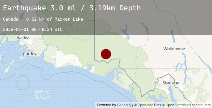
A 3.0 magnitude earthquake struck on 111 km NNW of Yakutat, Alaska, at Thu, 01 Jan 2026 08:48:24 GMT. Depth: 3.194km. Reviewed by USGS seismologists, this minor quake occurred at a magnitude type of ml.
Magnitude
3.0
ml
Source
USGS
Intensity
-
Earthquake Details
ConfirmedEvent IDusgs_us7000rlv8
Tsunami PotentialNo
Magnitude Typeml
Nearest Places
- Marker Lake8.6 km
- McArthur Peak9.6 km
- Mount Logan15.0 km
- Mount King George19.4 km
- Mount Queen Mary25.3 km
Comments
Join the discussion about this event.
Latest Earthquakes
2.7Mag
South of Java, Indonesia
Time1 hour ago
Depth11.34 km
SourceBMKG (Automatic)
2.7Mag
SOUTH OF JAVA, INDONESIA
Time1 hour ago
Depth11.00 km
SourceEMSC (Automatic)
2.3Mag
Timor Region
Time2 hours ago
Depth174.52 km
SourceBMKG (Automatic)
2.6Mag
KEPULAUAN ALOR, INDONESIA
Time2 hours ago
Depth179.00 km
SourceEMSC (Automatic)
2.9Mag
Java, Indonesia
Time2 hours ago
Depth10.00 km
SourceBMKG (Automatic)
Nearby Earthquakes
3.0Mag
SOUTHERN YUKON TERRITORY, CANADA
Time2 hours ago
Depth3.20 km
SourceEMSC (Automatic)
2.9Mag
SOUTHERN YUKON TERRITORY, CANADA
Time2 hours ago
Depth5.00 km
SourceEMSC (Automatic)
2.9Mag
101 km N of Yakutat, Alaska
Time2 hours ago
Depth5.00 km
SourceUSGS
3.1Mag
110 km NNW of Yakutat, Alaska
Time2 hours ago
Depth8.17 km
SourceUSGS
3.1Mag
SOUTHERN YUKON TERRITORY, CANADA
Time2 hours ago
Depth8.20 km
SourceEMSC (Automatic)