Earthquake Flores region, Indonesia
Mon, 16 Feb 2026 18:57:40 GMT
Time2 days ago
Location
-8.9589, 119.0529
Depth
106.4 KM
Event Summary
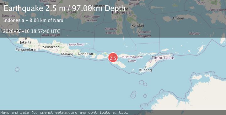
A 2.7 magnitude earthquake struck on Flores region, Indonesia, at Mon, 16 Feb 2026 18:57:40 GMT. Depth: 106.4453125km. Reviewed by VYT seismologists, this minor quake occurred at a magnitude type of earthquake.
Magnitude
2.7
earthquake
Source
VYT
Intensity
-
Agency Reports
2 Sources| Source | Magnitude | Depth | Time |
|---|---|---|---|
| VYTPrimary | 2.7 | 106 km | 2 days ago |
| BMKG | 2.5 | 97 km | 2 days ago |
Earthquake Details
AutomaticEvent IDvyt_1f8jtz0gdli2t
Tsunami PotentialNo
Magnitude Typeearthquake
Nearest Places
- Lutu Tinam15.4 km
- Nisa Kalongko18.3 km
- Toro Kalongko18.5 km
- Nisa Sobu18.7 km
- Toro Sobu18.8 km
Comments
Join the discussion about this event.
Latest Earthquakes
2.9Mag
Sumbawa Region, Indonesia
Time13 hours ago
Depth53.96 km
SourceBMKG
0.8Mag
Southern Alaska
Time13 hours ago
Depth15.50 km
SourceVYT (Automatic)
3.3Mag
Banda Sea
Time13 hours ago
Depth161.74 km
SourceVYT (Automatic)
4.4Mag
North of Halmahera, Indonesia
Time13 hours ago
Depth30.29 km
SourceBMKG
3.0Mag
Seram, Indonesia
Time13 hours ago
Depth3.59 km
SourceBMKG
Nearby Earthquakes
3.0Mag
FLORES REGION, INDONESIA
Time3 months ago
Depth89.00 km
SourceBMKG (Automatic)
2.4Mag
Flores Region, Indonesia
Time0 months ago
Depth10.00 km
SourceBMKG (Automatic)
3.0Mag
FLORES REGION, INDONESIA
Time3 months ago
Depth111.00 km
SourceBMKG (Automatic)
3.0Mag
SUMBA REGION, INDONESIA
Time5 years ago
Depth110.00 km
SourceDJA (Automatic)
3.0Mag
SUMBAWA REGION, INDONESIA
Time2 years ago
Depth63.00 km
SourceBMKG (Automatic)