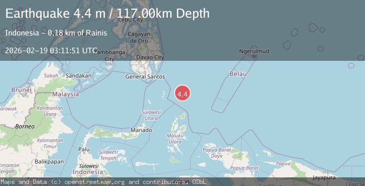
Earthquake North of Halmahera, Indonesia
Thu, 19 Feb 2026 03:11:56 GMT
Time1 hour ago
Location
3.9761, 128.3581
Depth
30.3 KM
Event Summary
A 4.4 magnitude earthquake struck on North of Halmahera, Indonesia, at Thu, 19 Feb 2026 03:11:56 GMT. Depth: 30.289986km. Reviewed by BMKG seismologists, this light quake occurred at a magnitude type of M.
Magnitude
4.4
M
Source
BMKG
Intensity
-
Agency Reports
1 Sources| Source | Magnitude | Depth | Time |
|---|---|---|---|
| BMKGPrimary | 4.4 | 30 km | 1 hour ago |
Earthquake Details
ManualEvent IDbmg2026dltz
Tsunami PotentialNo
Magnitude TypeM
Nearest Places
- Snellius Ridge39.8 km
- Talaud Trough104.5 km
- Morotai Basin115.6 km
- Pulau Karis121.3 km
- Tanjung Sopi150.0 km
Comments
Join the discussion about this event.
Latest Earthquakes
0.8Mag
Southern Alaska
Time1 hour ago
Depth15.50 km
SourceVYT (Automatic)
3.0Mag
Seram, Indonesia
Time1 hour ago
Depth3.59 km
SourceBMKG
3.4Mag
Rat Islands, Aleutian Islands, Alaska
Time1 hour ago
Depth112.18 km
SourceVYT (Automatic)
3.0Mag
Timor Region
Time1 hour ago
Depth49.07 km
SourceBMKG
3.2Mag
Southern Alaska
Time1 hour ago
Depth76.29 km
SourceVYT (Automatic)
Nearby Earthquakes
3.8Mag
north of Halmahera, Indonesia
Time3 days ago
Depth10.00 km
SourceVYT (Automatic)
3.7Mag
NORTH OF HALMAHERA, INDONESIA
Time4 days ago
Depth120.00 km
SourceBMKG (Automatic)
4.0Mag
North of Halmahera, Indonesia
Time4 days ago
Depth109.56 km
SourceBMKG
4.7Mag
North of Halmahera, Indonesia
Time5 days ago
Depth10.00 km
SourceBMKG
3.9Mag
North of Halmahera, Indonesia
Time5 days ago
Depth30.80 km
SourceBMKG