Earthquake California-Baja California border region
Sun, 10 May 2026 04:41:47 GMT
Time15 hours ago
Location
32.9021, -115.5699
Depth
10.4 KM
Event Summary
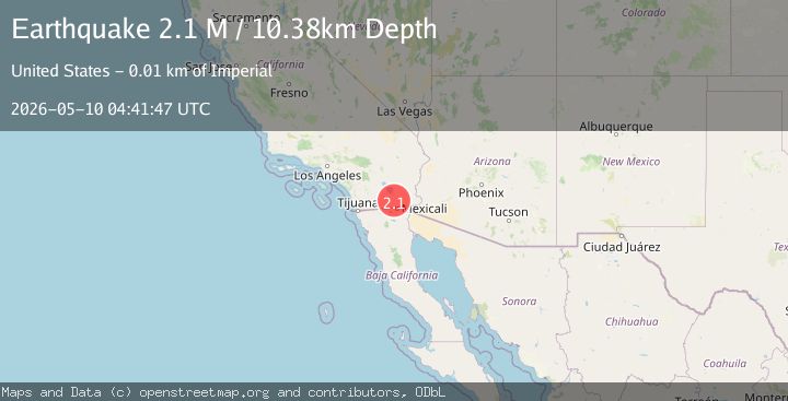
A 2.1 magnitude earthquake struck on California-Baja California border region, at Sun, 10 May 2026 04:41:47 GMT. Depth: 10.3759765625km. Reviewed by VYT seismologists, this minor quake occurred at a magnitude type of M.
Magnitude
2.1
M
Source
VYT
Intensity
I
Agency Reports
3 Sources| Source | Magnitude | Depth | Time |
|---|---|---|---|
| VYTPrimary | 2.1 | 10 km | 15 hours ago |
| USGS | 2.6 | 9 km | 15 hours ago |
| SCSN | 2.6 | 9 km | 15 hours ago |
Earthquake Details
AutomaticEvent IDvyt_1n5ys3bcv5eru
QualityC
Tsunami PotentialNo
Magnitude TypeM
Last Update15 hours ago
Used Stations51
Total Stations8
Nearest Places
Possibly felt by: 7.8K
- 6.1 km17.1K people
- 9.3 km25.9K people
- 12.3 km44K people
- 15.8 km2.3K people
- 16.6 km1.7K people
Felt Reports0
Did you feel this earthquake? Report it to help others.
No reports yet
Be the first to report this earthquake!
Latest Earthquakes
Loading...
Nearby Earthquakes
2.1Mag
California-Baja California border region
Time15 hours ago
Depth0.00 km
SourceVYT (Automatic)
1.4Mag
5 km SW of Brawley, CA
Time15 hours ago
Depth2.66 km
SourceUSGS (Automatic)
1.5Mag
1 km S of Brawley, CA
Time15 hours ago
Depth1.16 km
SourceUSGS (Automatic)
2.1Mag
California-Baja California border region
Time15 hours ago
Depth20.63 km
SourceVYT (Automatic)
2.1Mag
SOUTHERN CALIFORNIA
Time15 hours ago
Depth8.60 km
SourceSCSN (Automatic)