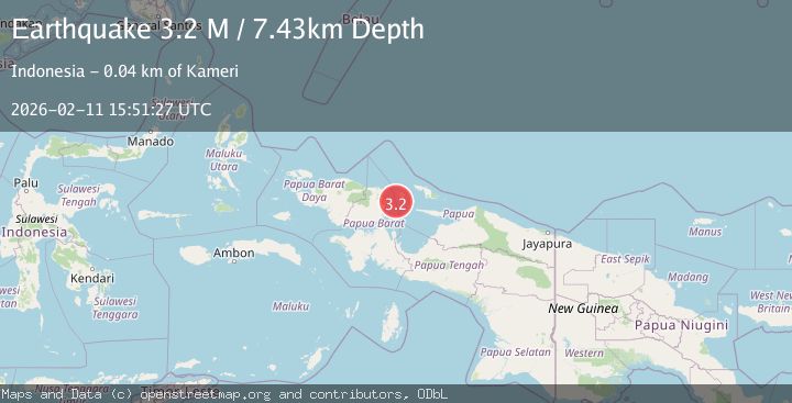
Earthquake near the north coast of Papua, Indonesia
Wed, 11 Feb 2026 15:51:25 GMT
Time6 days ago
Location
-1.3663, 134.7092
Depth
0.0 KM
Event Summary
A 3.4 magnitude earthquake struck on near the north coast of Papua, Indonesia, at Wed, 11 Feb 2026 15:51:25 GMT. Depth: 0km. Reviewed by VYT seismologists, this minor quake occurred at a magnitude type of earthquake.
Magnitude
3.4
earthquake
Source
VYT
Intensity
-
Agency Reports
2 Sources| Source | Magnitude | Depth | Time |
|---|---|---|---|
| VYTPrimary | 3.4 | 0 km | 6 days ago |
| BMKG | 3.3 | 6 km | 6 days ago |
Earthquake Details
AutomaticEvent IDvyt_1ods3pvehpkda
Tsunami PotentialNo
Magnitude Typeearthquake
Nearest Places
- Woinui Sorenia25.3 km
- Tanjung Aikar29.9 km
- Pulau Manim30.7 km
- Teluk Mansyokidori31.3 km
- Teluk Mansjokidori31.3 km
Comments
Join the discussion about this event.
Latest Earthquakes
1.7Mag
western Texas
Time4 minutes ago
Depth3.42 km
SourceVYT (Automatic)
3.5Mag
Seram, Indonesia
Time6 minutes ago
Depth0.00 km
SourceVYT (Automatic)
1.6Mag
54 km WNW of Toyah, Texas
Time12 minutes ago
Depth0.00 km
SourceUSGS (Automatic)
2.2Mag
West Papua Region, Indonesia
Time13 minutes ago
Depth26.69 km
SourceBMKG
1.2Mag
WESTERN TURKEY
Time14 minutes ago
Depth7.00 km
SourceAFAD (Automatic)
Nearby Earthquakes
2.4Mag
West Papua Region, Indonesia
Time3 weeks ago
Depth10.00 km
SourceBMKG (Automatic)
3.0Mag
NEAR N COAST OF PAPUA, INDONESIA
Time6 months ago
Depth10.00 km
SourceBMKG (Automatic)
4.0Mag
NEAR N COAST OF PAPUA, INDONESIA
Time1 year ago
Depth10.00 km
SourceBMKG (Automatic)
4.0Mag
NEAR N COAST OF PAPUA, INDONESIA
Time1 year ago
Depth10.00 km
SourceBMKG (Automatic)
4.0Mag
NEAR N COAST OF PAPUA, INDONESIA
Time5 years ago
Depth34.00 km
SourceNEIC (Automatic)