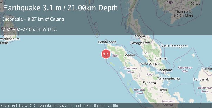
Earthquake northern Sumatra, Indonesia
Fri, 27 Feb 2026 06:35:05 GMT
Time1 hour ago
Location
4.7041, 95.5436
Depth
17.3 KM
Event Summary
A 3.1 magnitude earthquake struck on northern Sumatra, Indonesia, at Fri, 27 Feb 2026 06:35:05 GMT. Depth: 17.333984375km. Reviewed by VYT seismologists, this minor quake occurred at a magnitude type of earthquake.
Magnitude
3.1
earthquake
Source
VYT
Intensity
-
Agency Reports
2 Sources| Source | Magnitude | Depth | Time |
|---|---|---|---|
| VYTPrimary | 2.4 | 17 km | 1 hour ago |
| BMKG | 3.1 | 21 km | 1 hour ago |
Earthquake Details
AutomaticEvent IDvyt_1ou1bgyccegui
Tsunami PotentialNo
Magnitude Typeearthquake
Nearest Places
- 1.4 km
- 1.5 km
- 1.9 km
- 2.0 km
- 2.3 km
Comments
Join the discussion about this event.
Latest Earthquakes
2.7Mag
Coquimbo, Chile
Time1 hour ago
Depth5.62 km
SourceVYT (Automatic)
3.0Mag
Java, Indonesia
Time1 hour ago
Depth33.57 km
SourceBMKG
2.2Mag
ISLAND OF HAWAII, HAWAII
Time1 hour ago
Depth38.80 km
SourceHV (Automatic)
0.9Mag
8 km NW of The Geysers, CA
Time1 hour ago
Depth1.61 km
SourceUSGS (Automatic)
3.2Mag
Coquimbo, Chile
Time1 hour ago
Depth31.62 km
SourceVYT (Automatic)
Nearby Earthquakes
2.6Mag
NORTHERN SUMATRA, INDONESIA
Time1 month ago
Depth52.00 km
SourceBMKG (Automatic)
3.0Mag
Northern Sumatra, Indonesia
Time0 months ago
Depth50.37 km
SourceBMKG (Automatic)
3.0Mag
NORTHERN SUMATRA, INDONESIA
Time5 years ago
Depth60.00 km
SourceDJA (Automatic)
5.6Mag
NORTHERN SUMATRA, INDONESIA
Time21 years ago
Depth33.00 km
SourceEMSC (Automatic)
3.0Mag
NORTHERN SUMATRA, INDONESIA
Time1 month ago
Depth41.00 km
SourceBMKG (Automatic)