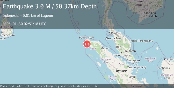
Earthquake Northern Sumatra, Indonesia
Fri, 30 Jan 2026 02:51:19 GMT
Time6 hours ago
Location
4.8304, 95.5831
Depth
46.3 KM
Event Summary
A 3.0 magnitude earthquake struck on Northern Sumatra, Indonesia, at Fri, 30 Jan 2026 02:51:19 GMT. Depth: 46.311234km. Reviewed by BMKG seismologists, this minor quake occurred at a magnitude type of M.
Magnitude
3.0
M
Source
BMKG
Intensity
-
Agency Reports
1 Sources| Source | Magnitude | Depth | Time |
|---|---|---|---|
| BMKGPrimary | 3.0 | 46 km | 6 hours ago |
Earthquake Details
AutomaticEvent IDbmg2026cbfg
Tsunami PotentialNo
Magnitude TypeM
Nearest Places
- Gle Ruboh1.2 km
- Gle Alue Aphan1.5 km
- Babahpieue1.7 km
- Teupinasan2.5 km
- Gle Alue Siti3.0 km
Comments
Join the discussion about this event.
Latest Earthquakes
3.7Mag
Talaud Islands, Indonesia
Time6 hours ago
Depth36.63 km
SourceBMKG (Automatic)
3.7Mag
Celebes Sea
Time6 hours ago
Depth541.33 km
SourceBMKG (Automatic)
1.6Mag
13 km ENE of Ridgecrest, CA
Time6 hours ago
Depth7.78 km
SourceUSGS (Automatic)
2.6Mag
WESTERN TURKEY
Time7 hours ago
Depth5.10 km
SourceKOERI (Automatic)
2.5Mag
Minahassa Peninsula, Sulawesi
Time7 hours ago
Depth15.04 km
SourceBMKG (Automatic)
Nearby Earthquakes
2.7Mag
Northern Sumatra, Indonesia
Time18 hours ago
Depth4.82 km
SourceBMKG (Automatic)
2.1Mag
Northern Sumatra, Indonesia
Time6 days ago
Depth4.51 km
SourceBMKG (Automatic)
2.4Mag
Northern Sumatra, Indonesia
Time3 days ago
Depth7.88 km
SourceBMKG (Automatic)
2.1Mag
Northern Sumatra, Indonesia
Time1 week ago
Depth8.15 km
SourceBMKG (Automatic)
3.4Mag
Northern Sumatra, Indonesia
Time2 days ago
Depth55.64 km
SourceBMKG (Automatic)