Earthquake Sulawesi, Indonesia
Thu, 12 Feb 2026 18:58:45 GMT
Time6 days ago
Location
-1.6336, 122.8034
Depth
650.3 KM
Event Summary
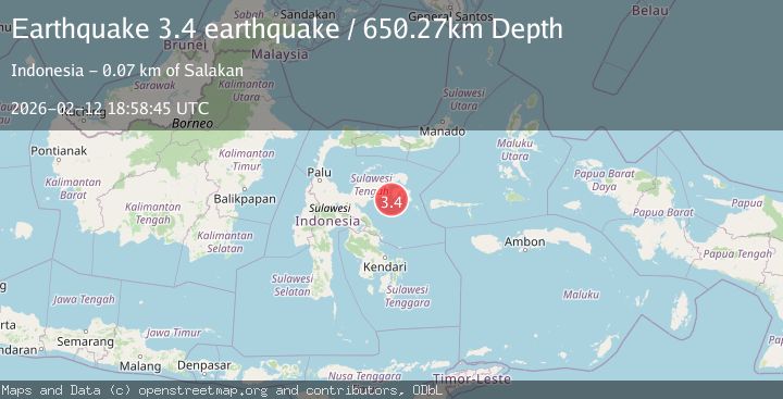
A 3.4 magnitude earthquake struck on Sulawesi, Indonesia, at Thu, 12 Feb 2026 18:58:45 GMT. Depth: 650.2685546875km. Reviewed by VYT seismologists, this minor quake occurred at a magnitude type of earthquake.
Magnitude
3.4
earthquake
Source
VYT
Intensity
-
Agency Reports
1 Sources| Source | Magnitude | Depth | Time |
|---|---|---|---|
| VYTPrimary | 3.4 | 650 km | 6 days ago |
Earthquake Details
AutomaticEvent IDvyt_1qd9x2i0hvrxa
Tsunami PotentialNo
Magnitude Typeearthquake
Nearest Places
- Pulau Delapan6.0 km
- Kepulauan Banyak6.5 km
- Tanjung Songoluli8.0 km
- Sungai Sellesek8.4 km
- Taepa8.8 km
Comments
Join the discussion about this event.
Latest Earthquakes
4.5Mag
Central Alaska
Time2 minutes ago
Depth7.81 km
SourceVYT (Automatic)
1.9Mag
1 km SSW of Pāhala, Hawaii
Time6 minutes ago
Depth28.47 km
SourceUSGS (Automatic)
1.5Mag
5 km NW of The Geysers, CA
Time7 minutes ago
Depth2.47 km
SourceUSGS (Automatic)
0.3Mag
10 km WNW of The Geysers, CA
Time9 minutes ago
Depth2.50 km
SourceUSGS (Automatic)
2.5Mag
Central Alaska
Time10 minutes ago
Depth112.55 km
SourceVYT (Automatic)
Nearby Earthquakes
2.0Mag
Sulawesi, Indonesia
Time3 days ago
Depth5.98 km
SourceVYT (Automatic)
2.6Mag
SULAWESI, INDONESIA
Time1 month ago
Depth14.00 km
SourceBMKG (Automatic)
5.0Mag
SULAWESI, INDONESIA
Time6 years ago
Depth40.00 km
SourceEMSC (Automatic)
6.8Mag
SULAWESI, INDONESIA
Time6 years ago
Depth10.00 km
SourceEMSC (Automatic)
4.0Mag
SULAWESI, INDONESIA
Time6 years ago
Depth11.00 km
SourceDJA (Automatic)