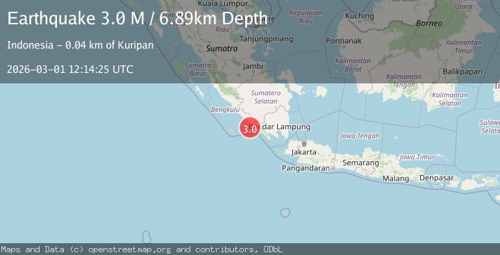
Earthquake southern Sumatra, Indonesia
Sun, 01 Mar 2026 12:14:22 GMT
Time9 hours ago
Location
-5.3055, 103.4321
Depth
9.6 KM
Event Summary
A 3.2 magnitude earthquake struck on southern Sumatra, Indonesia, at Sun, 01 Mar 2026 12:14:22 GMT. Depth: 9.6435546875km. Reviewed by VYT seismologists, this minor quake occurred at a magnitude type of earthquake.
Magnitude
3.2
earthquake
Source
VYT
Intensity
-
Agency Reports
2 Sources| Source | Magnitude | Depth | Time |
|---|---|---|---|
| VYTPrimary | 3.2 | 10 km | 9 hours ago |
| BMKG | 3.0 | 7 km | 9 hours ago |
Earthquake Details
AutomaticEvent IDvyt_1qov4nq8vqg86
Tsunami PotentialNo
Magnitude Typeearthquake
Nearest Places
- 42.9 km
- 43.2 km
- 43.2 km
- 43.7 km
- 44.0 km
Comments
Join the discussion about this event.
Latest Earthquakes
1.6Mag
1 km N of Simi Valley, CA
Time9 hours ago
Depth20.57 km
SourceUSGS (Automatic)
2.1Mag
Sweden
Time9 hours ago
Depth0.00 km
SourceVYT (Automatic)
1.7Mag
WESTERN TURKEY
Time9 hours ago
Depth8.30 km
SourceAFAD (Automatic)
2.9Mag
Coquimbo, Chile
Time9 hours ago
Depth31.74 km
SourceVYT (Automatic)
2.8Mag
WESTERN AUSTRALIA
Time9 hours ago
Depth2.50 km
SourceAUST (Automatic)
Nearby Earthquakes
3.0Mag
SOUTHERN SUMATRA, INDONESIA
Time4 months ago
Depth24.00 km
SourceBMKG (Automatic)
3.0Mag
SOUTHERN SUMATRA, INDONESIA
Time9 months ago
Depth26.00 km
SourceBMKG (Automatic)
3.0Mag
SOUTHERN SUMATRA, INDONESIA
Time7 months ago
Depth11.00 km
SourceBMKG (Automatic)
3.1Mag
SOUTHERN SUMATRA, INDONESIA
Time1 month ago
Depth12.00 km
SourceBMKG (Automatic)
3.0Mag
SOUTHERN SUMATRA, INDONESIA
Time3 years ago
Depth10.00 km
SourceDJA (Automatic)