Earthquake Southeastern Alaska
Fri, 13 Feb 2026 11:38:39 GMT
Time5 days ago
Location
59.9437, -139.2682
Depth
0.0 KM
Event Summary
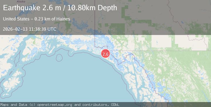
A 2.7 magnitude earthquake struck on Southeastern Alaska, at Fri, 13 Feb 2026 11:38:39 GMT. Depth: 0km. Reviewed by VYT seismologists, this minor quake occurred at a magnitude type of earthquake.
Magnitude
2.7
earthquake
Source
VYT
Intensity
-
Agency Reports
3 Sources| Source | Magnitude | Depth | Time |
|---|---|---|---|
| VYTPrimary | 2.4 | 0 km | 5 days ago |
| USGS | 2.7 | 5 km | 5 days ago |
| CN | 2.6 | 11 km | 5 days ago |
Earthquake Details
AutomaticEvent IDvyt_1r8ah21x0yn69
Tsunami PotentialNo
Magnitude Typeearthquake
Nearest Places
- Mount Stamy1.7 km
- Orange Glacier3.2 km
- Marble Point7.3 km
- Variegated Glacier8.3 km
- Alexander Glacier10.0 km
Comments
Join the discussion about this event.
Latest Earthquakes
2.7Mag
Tarapaca, Chile
Time2 minutes ago
Depth47.00 km
SourceVYT (Automatic)
1.3Mag
Southeastern Alaska
Time3 minutes ago
Depth0.00 km
SourceVYT (Automatic)
1.5Mag
British Columbia, Canada
Time5 minutes ago
Depth25.88 km
SourceVYT (Automatic)
2.9Mag
CENTRAL TURKEY
Time7 minutes ago
Depth7.00 km
SourceAFAD (Automatic)
2.9Mag
Antofagasta, Chile
Time10 minutes ago
Depth109.25 km
SourceVYT (Automatic)
Nearby Earthquakes
3.0Mag
SOUTHEASTERN ALASKA
Time3 years ago
Depth10.00 km
SourceNEIC (Automatic)
2.2Mag
Southeastern Alaska
Time5 days ago
Depth0.00 km
SourceVYT (Automatic)
3.0Mag
SOUTHERN YUKON TERRITORY, CANADA
Time7 years ago
Depth10.00 km
SourceNEIR (Automatic)
3.0Mag
SOUTHEASTERN ALASKA
Time7 years ago
Depth3.00 km
SourceNEIR (Automatic)
3.0Mag
SOUTHEASTERN ALASKA
Time6 years ago
Depth6.00 km
SourceNEIC (Automatic)