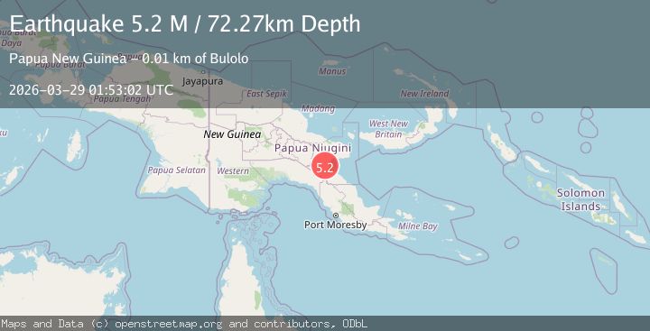
Earthquake eastern New Guinea region, Papua New Guinea
Sun, 29 Mar 2026 01:53:02 GMT
Low Quality Data Warning
This earthquake may be wrong/incorrect, it is recommended not to spread this information because there is a possibility that further updates are needed for data accuracy.
Time2 weeks ago
Location
-7.0906, 146.6507
Depth
72.3 KM
Event Summary
A 5.2 magnitude earthquake struck on eastern New Guinea region, Papua New Guinea, at Sun, 29 Mar 2026 01:53:02 GMT. Depth: 72.265625km. Reviewed by VYT seismologists, this moderate quake occurred at a magnitude type of M.
Magnitude
5.2
M
Source
VYT
Intensity
IV
Agency Reports
1 Sources| Source | Magnitude | Depth | Time |
|---|---|---|---|
| VYTPrimary | 5.2 | 72 km | 2 weeks ago |
Earthquake Details
AutomaticEvent IDvyt_23etb9bdmgg8x
QualityD
Tsunami PotentialNo
Magnitude TypeM
Last Update2 weeks ago
Used Stations5
Total Stations5
Nearest Places
Possibly felt by: 94.5K
- IVBulolo12.6 km16K people
- IIIWau29.1 km14.6K people
- IIILae55.9 km76.3K people
- IIKainantu124.4 km8.5K people
- IIKerema136.8 km5.6K people
- 142.8 km1.1K people
- IIIhu164.9 km
- IIGoroka178.9 km18.5K people
- IIKundiawa220.6 km9.4K people
- 228.7 km27.4K people
- 231.9 km6.2K people
- IMinj253.3 km
- 255.0 km28.2K people
- 262.0 km
- 271.0 km283.7K people
- 300.5 km33.6K people
- 301.4 km
- 306.9 km6.9K people
- 323.0 km
- 334.7 km1K people
- 347.0 km26.3K people
Felt Reports0
Did you feel this earthquake? Report it to help others.
No reports yet
Be the first to report this earthquake!
Latest Earthquakes
Loading...
Nearby Earthquakes
4.9Mag
eastern New Guinea region, Papua New Guinea
Time1 week ago
Depth60.30 km
SourceVYT (Automatic)
3.5Mag
eastern New Guinea region, Papua New Guinea
Time3 weeks ago
Depth0.00 km
SourceVYT (Automatic)
6.6Mag
EASTERN NEW GUINEA REG., P.N.G.
Time6 months ago
Depth97.50 km
SourceEMSC (Automatic)
5.0Mag
EASTERN NEW GUINEA REG., P.N.G.
Time11 months ago
Depth45.00 km
SourceEMSC (Automatic)
5.5Mag
EASTERN NEW GUINEA REG., P.N.G.
Time1 year ago
Depth67.00 km
SourceEMSC (Automatic)