Earthquake California-Baja California border region
Mon, 23 Feb 2026 15:48:37 GMT
Time6 hours ago
Location
32.9977, -115.8735
Depth
15.6 KM
Event Summary
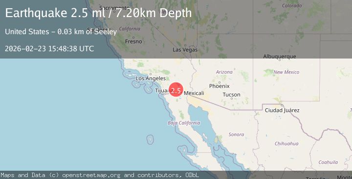
A 2.6 magnitude earthquake struck on California-Baja California border region, at Mon, 23 Feb 2026 15:48:37 GMT. Depth: 15.625km. Reviewed by VYT seismologists, this minor quake occurred at a magnitude type of earthquake.
Magnitude
2.6
earthquake
Source
VYT
Intensity
-
Agency Reports
3 Sources| Source | Magnitude | Depth | Time |
|---|---|---|---|
| VYTPrimary | 2.6 | 16 km | 6 hours ago |
| USGS | 2.5 | 7 km | 6 hours ago |
| SCSN | 2.5 | 7 km | 6 hours ago |
Earthquake Details
AutomaticEvent IDvyt_2ptgv30r2mzz5
Tsunami PotentialNo
Magnitude Typeearthquake
Nearest Places
- 5.3 km
- 6.2 km
- 6.6 km
- 11.4 km
- 12.2 km
Comments
Join the discussion about this event.
Latest Earthquakes
3.1Mag
Fox Islands, Aleutian Islands, Alaska
Time6 minutes ago
Depth2.32 km
SourceVYT (Automatic)
2.0Mag
northern Alaska
Time6 minutes ago
Depth154.66 km
SourceVYT (Automatic)
0.7Mag
15 km W of Johannesburg, CA
Time9 minutes ago
Depth9.19 km
SourceUSGS (Automatic)
3.0Mag
Antofagasta, Chile
Time14 minutes ago
Depth166.02 km
SourceVYT (Automatic)
3.6Mag
Fox Islands, Aleutian Islands, Alaska
Time15 minutes ago
Depth2.32 km
SourceVYT (Automatic)
Nearby Earthquakes
3.0Mag
SOUTHERN CALIFORNIA
Time3 years ago
Depth15.00 km
SourceNEIC (Automatic)
0.7Mag
23 km NNE of Ocotillo, CA
Time21 hours ago
Depth8.87 km
SourceUSGS (Automatic)
3.0Mag
SOUTHERN CALIFORNIA
Time2 years ago
Depth7.00 km
SourceNEIC (Automatic)
3.0Mag
SOUTHERN CALIFORNIA
Time10 years ago
Depth10.00 km
SourceNEIR (Automatic)
2.2Mag
SOUTHERN CALIFORNIA
Time1 month ago
Depth7.50 km
SourceSCSN (Automatic)