Earthquake Kodiak Island region, Alaska
Fri, 13 Mar 2026 03:20:54 GMT
Time3 hours ago
Location
57.8786, -154.4031
Depth
115.2 KM
Event Summary
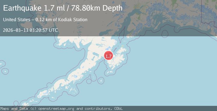
A 1.7 magnitude earthquake struck on Kodiak Island region, Alaska, at Fri, 13 Mar 2026 03:20:54 GMT. Depth: 115.234375km. Reviewed by VYT seismologists, this minor quake occurred at a magnitude type of M.
Magnitude
1.7
M
Source
VYT
Intensity
-
Agency Reports
2 Sources| Source | Magnitude | Depth | Time |
|---|---|---|---|
| VYTPrimary | 1.7 | 115 km | 3 hours ago |
| USGS | 1.7 | 79 km | 3 hours ago |
Earthquake Details
AutomaticEvent IDvyt_2wusr1jm7fjt
QualityC
Tsunami PotentialNo
Magnitude TypeM
Last Update3 hours ago
Total Stations14
Nearest Places
- 107.5 km
- 118.7 km
- 256.0 km
- 257.7 km
- 258.5 km
Felt Reports0
Did you feel this earthquake? Report it to help others.
No reports yet
Be the first to report this earthquake!
Latest Earthquakes
Loading...
Nearby Earthquakes
3.1Mag
Kodiak Island region, Alaska
Time4 hours ago
Depth70.43 km
SourceVYT (Automatic)
1.1Mag
Alaska Peninsula
Time5 hours ago
Depth10.00 km
SourceVYT (Automatic)
1.4Mag
Alaska Peninsula
Time5 hours ago
Depth33.08 km
SourceVYT (Automatic)
0.8Mag
Alaska Peninsula
Time6 hours ago
Depth0.12 km
SourceVYT (Automatic)
0.8Mag
Alaska Peninsula
Time8 hours ago
Depth13.31 km
SourceVYT (Automatic)