Earthquake Kepulauan Talaud, Indonesia
Fri, 27 Feb 2026 13:39:37 GMT
Time2 days ago
Location
4.6369, 127.4274
Depth
12.3 KM
Event Summary
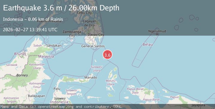
A 4.2 magnitude earthquake struck on Kepulauan Talaud, Indonesia, at Fri, 27 Feb 2026 13:39:37 GMT. Depth: 12.3291015625km. Reviewed by VYT seismologists, this light quake occurred at a magnitude type of earthquake.
Magnitude
4.2
earthquake
Source
VYT
Intensity
-
Agency Reports
2 Sources| Source | Magnitude | Depth | Time |
|---|---|---|---|
| VYTPrimary | 4.2 | 12 km | 2 days ago |
| BMKG | 3.6 | 26 km | 2 days ago |
Earthquake Details
AutomaticEvent IDvyt_2y0tbd36fmobh
Tsunami PotentialNo
Magnitude Typeearthquake
Nearest Places
- 29.7 km
- 29.7 km
- 29.9 km
- 32.3 km
- 32.8 km
Comments
Join the discussion about this event.
Latest Earthquakes
1.8Mag
85 km NE of Tonopah, Nevada
Time1 hour ago
Depth6.04 km
SourceUSGS (Automatic)
1.8Mag
81 km NE of Tonopah, Nevada
Time1 hour ago
Depth11.57 km
SourceUSGS (Automatic)
1.6Mag
94 km NE of Tonopah, Nevada
Time1 hour ago
Depth12.22 km
SourceUSGS (Automatic)
3.0Mag
southeast central Pacific Ocean
Time1 hour ago
Depth369.75 km
SourceVYT (Automatic)
1.1Mag
23 km N of Borrego Springs, CA
Time2 hours ago
Depth6.07 km
SourceUSGS (Automatic)
Nearby Earthquakes
3.0Mag
Kepulauan Talaud, Indonesia
Time3 hours ago
Depth124.63 km
SourceVYT (Automatic)
5.9Mag
KEPULAUAN TALAUD, INDONESIA
Time2 years ago
Depth108.00 km
SourceEMSC (Automatic)
4.0Mag
KEPULAUAN TALAUD, INDONESIA
Time6 years ago
Depth134.00 km
SourceDJA (Automatic)
5.2Mag
KEPULAUAN TALAUD, INDONESIA
Time9 years ago
Depth71.00 km
SourceEMSC (Automatic)
4.0Mag
KEPULAUAN TALAUD, INDONESIA
Time4 years ago
Depth10.00 km
SourcePIVS (Automatic)