Earthquake western Texas
Thu, 12 Feb 2026 15:36:33 GMT
Time2 weeks ago
Location
32.3553, -102.0675
Depth
1.0 KM
Event Summary
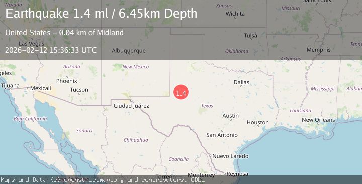
A 1.7 magnitude earthquake struck on western Texas, at Thu, 12 Feb 2026 15:36:33 GMT. Depth: 0.9765625km. Reviewed by VYT seismologists, this minor quake occurred at a magnitude type of earthquake.
Magnitude
1.7
earthquake
Source
VYT
Intensity
-
Agency Reports
2 Sources| Source | Magnitude | Depth | Time |
|---|---|---|---|
| VYTPrimary | 1.7 | 1 km | 2 weeks ago |
| USGS | 1.4 | 6 km | 2 weeks ago |
Earthquake Details
AutomaticEvent IDvyt_338tou9uafp98
Tsunami PotentialNo
Magnitude Typeearthquake
Nearest Places
- 2.8 km
- 4.4 km
- 5.4 km
- 5.8 km
- 5.9 km
Comments
Join the discussion about this event.
Latest Earthquakes
2.1Mag
Tarapaca, Chile
Time12 hours ago
Depth5.00 km
SourceVYT (Automatic)
2.3Mag
Sumbawa Region, Indonesia
Time12 hours ago
Depth10.00 km
SourceBMKG
2.7Mag
offshore Coquimbo, Chile
Time13 hours ago
Depth11.96 km
SourceVYT (Automatic)
3.3Mag
Seram, Indonesia
Time13 hours ago
Depth188.48 km
SourceVYT (Automatic)
1.3Mag
Southeastern Alaska
Time13 hours ago
Depth11.47 km
SourceVYT (Automatic)
Nearby Earthquakes
1.9Mag
36 km NW of Stanton, Texas
Time2 weeks ago
Depth5.52 km
SourceUSGS (Automatic)
1.1Mag
37 km NW of Stanton, Texas
Time3 weeks ago
Depth4.03 km
SourceUSGS (Automatic)
1.3Mag
38 km NW of Stanton, Texas
Time1 month ago
Depth8.35 km
SourceUSGS (Automatic)
1.3Mag
37 km NW of Stanton, Texas
Time0 months ago
Depth8.80 km
SourceUSGS (Automatic)
1.5Mag
37 km NW of Stanton, Texas
Time1 month ago
Depth4.38 km
SourceUSGS (Automatic)