Earthquake southern Sumatra, Indonesia
Sun, 01 Mar 2026 13:40:12 GMT
Time3 hours ago
Location
-4.9755, 102.9860
Depth
38.6 KM
Event Summary
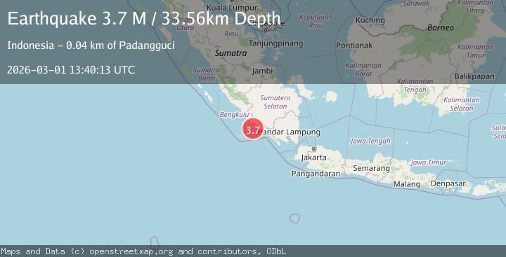
A 4.1 magnitude earthquake struck on southern Sumatra, Indonesia, at Sun, 01 Mar 2026 13:40:12 GMT. Depth: 38.57421875km. Reviewed by VYT seismologists, this light quake occurred at a magnitude type of earthquake.
Magnitude
4.1
earthquake
Source
VYT
Intensity
-
Agency Reports
2 Sources| Source | Magnitude | Depth | Time |
|---|---|---|---|
| VYTPrimary | 4.1 | 39 km | 3 hours ago |
| BMKG | 3.7 | 34 km | 3 hours ago |
Earthquake Details
AutomaticEvent IDvyt_36sgqhp7fu1yg
Tsunami PotentialNo
Magnitude Typeearthquake
Nearest Places
- 42.0 km
- 42.3 km
- 43.1 km
- 43.2 km
- 43.8 km
Comments
Join the discussion about this event.
Latest Earthquakes
1.8Mag
79 km NE of Tonopah, Nevada
Time4 minutes ago
Depth0.64 km
SourceUSGS (Automatic)
2.9Mag
Flores region, Indonesia
Time6 minutes ago
Depth264.65 km
SourceVYT (Automatic)
4.1Mag
Tarapaca, Chile
Time6 minutes ago
Depth123.90 km
SourceVYT (Automatic)
1.9Mag
Fox Islands, Aleutian Islands, Alaska
Time7 minutes ago
Depth25.15 km
SourceVYT (Automatic)
0.8Mag
9 km WNW of The Geysers, CA
Time8 minutes ago
Depth2.52 km
SourceUSGS (Automatic)
Nearby Earthquakes
5.0Mag
SOUTHERN SUMATRA, INDONESIA
Time13 years ago
Depth71.00 km
SourceEMSC (Automatic)
5.8Mag
SOUTHERN SUMATRA, INDONESIA
Time16 years ago
Depth60.00 km
SourceEMSC (Automatic)
4.0Mag
SOUTHERN SUMATRA, INDONESIA
Time1 year ago
Depth27.00 km
SourceBMKG (Automatic)
4.0Mag
SOUTHERN SUMATRA, INDONESIA
Time2 years ago
Depth23.00 km
SourceBMKG (Automatic)
5.1Mag
SOUTHERN SUMATRA, INDONESIA
Time14 years ago
Depth60.00 km
SourceEMSC (Automatic)