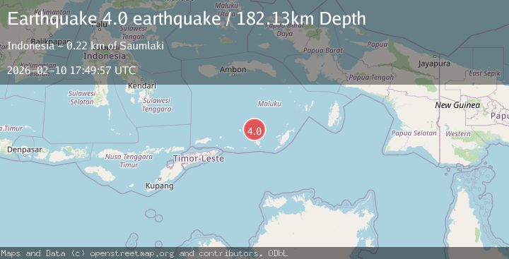
Earthquake Banda Sea
Tue, 10 Feb 2026 17:49:57 GMT
Time1 week ago
Location
-7.0973, 129.5178
Depth
182.1 KM
Event Summary
A 4.7 magnitude earthquake struck on Banda Sea, at Tue, 10 Feb 2026 17:49:57 GMT. Depth: 182.12890625km. Reviewed by VYT seismologists, this light quake occurred at a magnitude type of earthquake.
Magnitude
4.7
earthquake
Source
VYT
Intensity
-
Agency Reports
4 Sources| Source | Magnitude | Depth | Time |
|---|---|---|---|
| VYTPrimary | 4.0 | 182 km | 1 week ago |
| BMKG | 4.7 | 146 km | 1 week ago |
| USGS | 4.3 | 160 km | 1 week ago |
| EMSC | 4.3 | 138 km | 1 week ago |
Earthquake Details
AutomaticEvent IDvyt_37t9xp39g26ln
Tsunami PotentialNo
Magnitude Typeearthquake
Nearest Places
- Damar Ridge29.4 km
- Tanjung Sifanandrierna37.4 km
- Wotai38.1 km
- Bumai38.7 km
- Pulau Nila39.8 km
Comments
Join the discussion about this event.
Latest Earthquakes
1.7Mag
Central Alaska
Time6 minutes ago
Depth86.30 km
SourceVYT (Automatic)
4.6Mag
Tarapaca, Chile
Time8 minutes ago
Depth111.45 km
SourceVYT (Automatic)
2.5Mag
IONIAN SEA
Time20 minutes ago
Depth13.20 km
SourceNOA (Automatic)
2.4Mag
Tarapaca, Chile
Time21 minutes ago
Depth0.00 km
SourceVYT (Automatic)
0.8Mag
4 km NW of The Geysers, CA
Time25 minutes ago
Depth3.24 km
SourceUSGS (Automatic)
Nearby Earthquakes
5.1Mag
KEPULAUAN BABAR, INDONESIA
Time5 years ago
Depth142.00 km
SourceEMSC (Automatic)
3.6Mag
Banda Sea
Time1 week ago
Depth179.97 km
SourceBMKG (Automatic)
5.0Mag
KEPULAUAN BABAR, INDONESIA
Time5 years ago
Depth117.00 km
SourceEMSC (Automatic)
5.1Mag
KEPULAUAN BABAR, INDONESIA
Time7 years ago
Depth132.00 km
SourceEMSC (Automatic)
5.0Mag
KEPULAUAN BABAR, INDONESIA
Time16 years ago
Depth142.00 km
SourceEMSC (Automatic)