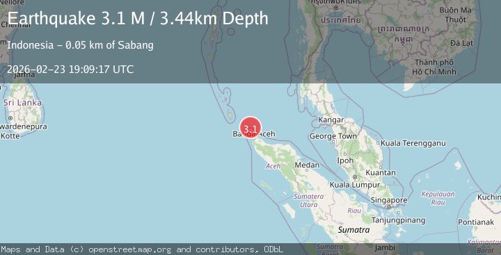
Earthquake northern Sumatra, Indonesia
Mon, 23 Feb 2026 19:09:22 GMT
Time1 hour ago
Location
5.9729, 95.1584
Depth
18.1 KM
Event Summary
A 2.6 magnitude earthquake struck on northern Sumatra, Indonesia, at Mon, 23 Feb 2026 19:09:22 GMT. Depth: 18.06640625km. Reviewed by VYT seismologists, this minor quake occurred at a magnitude type of earthquake.
Magnitude
2.6
earthquake
Source
VYT
Intensity
-
Agency Reports
1 Sources| Source | Magnitude | Depth | Time |
|---|---|---|---|
| VYTPrimary | 2.6 | 18 km | 1 hour ago |
Earthquake Details
AutomaticEvent IDvyt_3bywx4g0lmk11
Tsunami PotentialNo
Magnitude Typeearthquake
Nearest Places
- 9.7 km
- 10.0 km
- 10.2 km
- 10.4 km
- 11.0 km
Comments
Join the discussion about this event.
Latest Earthquakes
1.6Mag
Central Alaska
Time1 hour ago
Depth10.00 km
SourceVYT (Automatic)
2.7Mag
Fox Islands, Aleutian Islands, Alaska
Time1 hour ago
Depth5.74 km
SourceVYT (Automatic)
3.2Mag
Fox Islands, Aleutian Islands, Alaska
Time1 hour ago
Depth3.54 km
SourceVYT (Automatic)
1.5Mag
17 km SSE of Mammoth Lakes, CA
Time1 hour ago
Depth3.16 km
SourceUSGS (Automatic)
2.6Mag
DOMINICAN REPUBLIC REGION
Time1 hour ago
Depth46.70 km
SourceNEIC (Automatic)
Nearby Earthquakes
3.0Mag
NICOBAR ISLANDS, INDIA REGION
Time9 months ago
Depth5.00 km
SourceBMKG (Automatic)
2.5Mag
Northern Sumatra, Indonesia
Time3 weeks ago
Depth198.72 km
SourceBMKG (Automatic)
3.0Mag
NICOBAR ISLANDS, INDIA REGION
Time1 year ago
Depth10.00 km
SourceBMKG (Automatic)
5.2Mag
NICOBAR ISLANDS, INDIA REGION
Time7 months ago
Depth35.00 km
SourceEMSC (Automatic)
3.0Mag
NICOBAR ISLANDS, INDIA REGION
Time11 months ago
Depth10.00 km
SourceBMKG (Automatic)