Earthquake southern Sumatra, Indonesia
Tue, 24 Feb 2026 21:23:53 GMT
Time1 hour ago
Location
-0.9959, 99.9998
Depth
51.5 KM
Event Summary
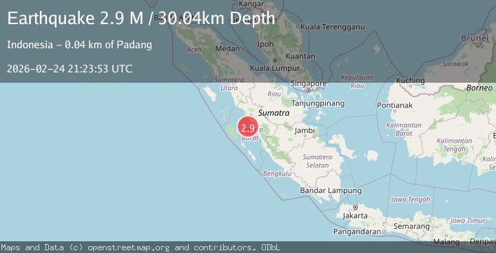
A 3.0 magnitude earthquake struck on southern Sumatra, Indonesia, at Tue, 24 Feb 2026 21:23:53 GMT. Depth: 51.513671875km. Reviewed by VYT seismologists, this minor quake occurred at a magnitude type of earthquake.
Magnitude
3.0
earthquake
Source
VYT
Intensity
-
Agency Reports
2 Sources| Source | Magnitude | Depth | Time |
|---|---|---|---|
| VYTPrimary | 3.0 | 52 km | 1 hour ago |
| BMKG | 2.9 | 30 km | 1 hour ago |
Earthquake Details
AutomaticEvent IDvyt_3hwz4exkuypid
Tsunami PotentialNo
Magnitude Typeearthquake
Nearest Places
- 10.1 km
- 16.6 km
- 17.6 km
- 19.5 km
- 22.6 km
Comments
Join the discussion about this event.
Latest Earthquakes
1.9Mag
Central Alaska
Time20 minutes ago
Depth100.46 km
SourceVYT (Automatic)
2.0Mag
Albania
Time23 minutes ago
Depth28.32 km
SourceVYT (Automatic)
2.7Mag
northern Colombia
Time24 minutes ago
Depth144.53 km
SourceVYT (Automatic)
2.3Mag
Fox Islands, Aleutian Islands, Alaska
Time27 minutes ago
Depth2.08 km
SourceVYT (Automatic)
2.6Mag
Java, Indonesia
Time31 minutes ago
Depth22.98 km
SourceBMKG
Nearby Earthquakes
3.0Mag
KEP. MENTAWAI REGION, INDONESIA
Time4 years ago
Depth10.00 km
SourceDJA (Automatic)
5.1Mag
SOUTHERN SUMATRA, INDONESIA
Time17 years ago
Depth100.00 km
SourceEMSC (Automatic)
3.0Mag
SOUTHERN SUMATRA, INDONESIA
Time4 years ago
Depth10.00 km
SourceDJA (Automatic)
3.0Mag
SOUTHERN SUMATRA, INDONESIA
Time2 years ago
Depth37.00 km
SourceBMKG (Automatic)
7.6Mag
SOUTHERN SUMATRA, INDONESIA
Time16 years ago
Depth89.00 km
SourceEMSC (Automatic)