Earthquake southern Sumatra, Indonesia
Sun, 22 Feb 2026 15:35:41 GMT
Time1 hour ago
Location
-0.7472, 99.1339
Depth
38.9 KM
Event Summary
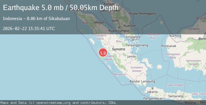
A 5.2 magnitude earthquake struck on southern Sumatra, Indonesia, at Sun, 22 Feb 2026 15:35:41 GMT. Depth: 38.9404296875km. Reviewed by VYT seismologists, this moderate quake occurred at a magnitude type of earthquake.
Magnitude
5.2
earthquake
Source
VYT
Intensity
-
Agency Reports
1 Sources| Source | Magnitude | Depth | Time |
|---|---|---|---|
| VYTPrimary | 5.2 | 39 km | 1 hour ago |
Earthquake Details
AutomaticEvent IDvyt_3lmcy5ej7v042
Tsunami PotentialNo
Magnitude Typeearthquake
Nearest Places
- 30.9 km
- 32.5 km
- 32.6 km
- 34.4 km
- 36.1 km
Comments
Join the discussion about this event.
Latest Earthquakes
1.4Mag
Washington
Time1 hour ago
Depth0.00 km
SourceVYT (Automatic)
2.8Mag
Minahassa Peninsula, Sulawesi
Time1 hour ago
Depth132.85 km
SourceBMKG
3.1Mag
Celebes Sea
Time1 hour ago
Depth148.80 km
SourceVYT (Automatic)
3.1Mag
OFF E. COAST OF N. ISLAND, N.Z.
Time1 hour ago
Depth23.80 km
SourceGNS (Automatic)
1.7Mag
Central Alaska
Time1 hour ago
Depth45.53 km
SourceVYT (Automatic)
Nearby Earthquakes
3.0Mag
SOUTHERN SUMATRA, INDONESIA
Time5 months ago
Depth17.00 km
SourceBMKG (Automatic)
4.0Mag
SOUTHERN SUMATRA, INDONESIA
Time3 years ago
Depth10.00 km
SourceDJA (Automatic)
3.6Mag
Southern Sumatra, Indonesia
Time3 weeks ago
Depth41.61 km
SourceBMKG (Automatic)
5.1Mag
SOUTHERN SUMATRA, INDONESIA
Time14 years ago
Depth46.00 km
SourceEMSC (Automatic)
4.0Mag
SOUTHERN SUMATRA, INDONESIA
Time3 years ago
Depth61.00 km
SourceDJA (Automatic)