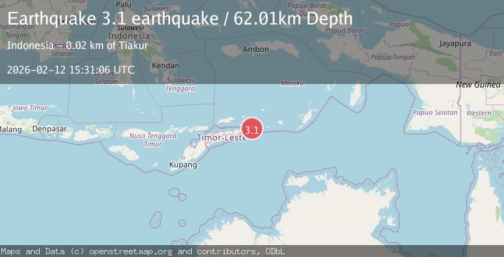
Earthquake Timor region, Indonesia
Thu, 12 Feb 2026 15:31:06 GMT
Time6 days ago
Location
-8.3090, 127.9489
Depth
62.0 KM
Event Summary
A 3.1 magnitude earthquake struck on Timor region, Indonesia, at Thu, 12 Feb 2026 15:31:06 GMT. Depth: 62.01171875km. Reviewed by VYT seismologists, this minor quake occurred at a magnitude type of earthquake.
Magnitude
3.1
earthquake
Source
VYT
Intensity
-
Agency Reports
1 Sources| Source | Magnitude | Depth | Time |
|---|---|---|---|
| VYTPrimary | 3.1 | 62 km | 6 days ago |
Earthquake Details
AutomaticEvent IDvyt_3t0pip6xrd87v
Tsunami PotentialNo
Magnitude Typeearthquake
Nearest Places
- Tanjung Tut Nei6.8 km
- Niama7.1 km
- Klis10.3 km
- Opinyor10.4 km
- Pantai Gergain10.9 km
Comments
Join the discussion about this event.
Latest Earthquakes
3.4Mag
Rat Islands, Aleutian Islands, Alaska
Time2 hours ago
Depth112.18 km
SourceVYT (Automatic)
2.8Mag
Timor Region
Time2 hours ago
Depth49.07 km
SourceBMKG
3.2Mag
Southern Alaska
Time2 hours ago
Depth76.29 km
SourceVYT (Automatic)
3.8Mag
Nicaragua
Time2 hours ago
Depth342.53 km
SourceVYT (Automatic)
1.5Mag
Tarapaca, Chile
Time2 hours ago
Depth1.95 km
SourceVYT (Automatic)
Nearby Earthquakes
5.0Mag
TIMOR SEA
Time14 years ago
Depth67.00 km
SourceEMSC (Automatic)
5.8Mag
EAST TIMOR REGION
Time12 years ago
Depth25.00 km
SourceEMSC (Automatic)
3.8Mag
Banda Sea
Time1 week ago
Depth126.89 km
SourceBMKG (Automatic)
5.0Mag
TIMOR SEA
Time3 years ago
Depth10.00 km
SourceEMSC (Automatic)
3.9Mag
KEPULAUAN BARAT DAYA, INDONESIA
Time1 month ago
Depth136.00 km
SourceBMKG (Automatic)